QUODCUMQUE FACIENDUM : NIMIS FACIEMUS
Contents
Editorial
Take A Bow
Response to last months appeal for paper has been very good
indeed. One is tempted to wonder if the
motto had anything to do with it, because club members have done it to excess
and our supplies of paper are now in a much more healthy state.
Dilemma
When articles are in short supply – as at present – the
editor faces a number of dilemmas (if this is possible, and I reckon with the
B.B., it is!) If he fills a B.B. up with
specialist information, most members will consider this to be a waste of
paper. If he sends out a very thin B.B.
containing only the articles he happens to have by him this would be considered
a waste of covers and postage. If he
waits until he can produce a standard B.B. containing information of general
interest, he is likely to be accuse of letting down the club by not providing a
regular source of information.
Under these circumstances, it becomes very difficult to
win. Apart from the reasons given above,
the editor feels that the article he is including in this month’s B.B. might
possibly be said to earn its keep if it persuades some active caver to do some
work along the lines suggested. We hear
people say from time to time that there is nothing much to do much to do on
Mendip. This could be the chance for
somebody to prove such people wrong!
Published Elsewhere
While on the subject of articles, we note that from time to
time club members send in their work to publications other than the B.B. This is, of course, perfectly fair and in any
case there is usually some good reason why an author decides to let a
particular piece of work go to a journal which will reach the audience he has
in mind.
However, most members of the B.E.C. rarely read other
publications – and rely almost entirely on the B.B. for keeping abreast of what
is going on. There would thus be no harm
in authors who have published elsewhere submitting their work for subsequent
publication in the B.B. The original
source will be brought to the attention of B.B. readers in every case should
the author so desire.
Alfie
Preliminary Report on Reynolds Rift
We have received the following
from the Chelm’s Coombe Caving Club – a branch of the National Tower Testing
Station Sports and Social Club.
On the 6th of December, 1973, members of the Chelm’s Coombe
Caving Club broke through into an open cave passage in their dig ‘Reynoldss
Rift’ at the National Tower Testing Station, Cheddar.
We have so far discovered two hundred feet of passage with a
vertical range of fifty feet. A hundred
feet of this is stream passage.
No visits are allowed at the present time, while clearance
work is done, while a report is prepared for the National Tower Testing
Station. Digging will be continued by
club members.
The situation as far as access is concerned will be in the
full report which will follow when clearance is completed.
J. Aylott,
Secretary, C.C.C.C.
Addition to members’ addresses.
828 Nicolette Abell, Ardtraskart,
*****************************************
Members might like to know that we are still following up
information about chemical lights but are not yet in a position to give members
any further information. This will be
done as soon as possible.
*****************************************
Annual Subscriptions for 1974 should be sent to BARRY
WILTON. Members are advised not to leave
this chore until the last minute, because there is always a risk that they will
get removed from the B.B. circulation list in May.
Limestone & Caves of N.W.
England
A
Review of this important book, which will be in the club library, by Andrew
Nichols.
Edited by A.C.
(David & Charles, for the B.C.R.A. 1974. Price £6.95 )
This, the first of a series covering each of the four major
British caving areas, is intended, as Trevor Ford says in his foreword, to
provide a factual survey for not only the sporting and scientific caver, but
teachers and students as well as landowners; quarry industries and water
authorities. That, I suspect, is a pious
hope. It is a book for cavers, and one
which they will find invaluable.
It’s a large book. 470 pages covering the twelve mile wide limestone strip between
East, which contains most of the major systems of the Dales.
There are two sections. The first opens with a discussion of the overall geology,
spelaeomorphology and hydrology; continues with three chapters on the
characteristics and behaviour of karst water and ends with a review of biospelaeological
and archaeological work. These 180 pages
are hard going for the non-specialist, particularly without a glossary – though
the authors may fairly expect their readers to have a certain amount of
knowledge. Initially, it may disappoint
those who expected the same excitement from the writing as from the caves, but
a second reading should dispel that because, once absorbed, it adds enormously
to the value of the rest of the book. It
also represents a great deal of dedicated work. There is, for example, a casual reference in one chapter to ‘water
sampling from 68 sites over a period of 7 years’ – much of it new and all of it
important.
Archaeological work in the Dales was predominantly 19th
century and yielded little from the few inhabited caves, so this chapter
continued to disappoint me, though that presumably will not be so with the corresponding
reviews of the other caving areas in the series.
The second, and larger, section deals with the caves
themselves. There is a chapter on each
of the 12 areas into which the karst has been sub-divided, with a final
discussion of the total chronology. This
is why the book will be bought and what it will be judged on. The B.C.R.A. has done well in assembling a
team of writers so expert on their particular areas. All the chapters are good and several are
outstanding. Tony Waltham’s is unusually
successful in his disentanglement of the multi-phased development of the Lost
Johns-Short Drop-Gavel system. Dave
Brooks’s discussion of Kingsdale is a masterpiece of clear, precise and
jargon-free analysis, and his description of Black Keld brings out all the
excitement of one of
major hydrological systems.
No serious caver – sporting or scientific – can afford to be
ignorant of the caves of North West England, and those who do know a little of
the area will have their favourite cave s and theories; and may be affronted to
find that they may not have been given the coverage that they think they
deserve. Lower Easegill Pot, I am
convinced, merits more that a few lines on page 251! Understandably, not everything can be put
into 470 pages and Tony Waltham as editor has had to aim for width rather than
for depth for this is a survey – not a thesis.
Nevertheless, I was surprised by some omissions and
editorial emphasis. Chapter 19, for
instance, on Ribblesdale refers to the massive hydrological system of Brants
Gill Head (the Penyghent-Fountains Fell master cave) and proceeds to dismiss
it in three pages – while the spelaeologically piffling
area, however interesting to the theorist, has a lavish 26 pages. The Black Keld system has only a short,
though excellent, chapter.
system, is outside the scope of the book altogether. The necessary arbitrary division into twelve
areas has had the effect that chapters 14 to 16 are treated almost -without
reference to each other and with no mention of the now respectable Three
Counties theory. Cavers more familiar
with other areas covered by the book will be able possibly to find other
examples.
However, the sheer size and importance of the area covered
must be blamed for what omissions do exist. The material included is accurate and thoroughly discussed, with many
gaps in present knowledge valuably pointed out. Not only, is the book recent; it is, unusually for a caving book, right
up to date at the time of writing.
The presentation is not, unfortunately, up to the standard
of the text. There is an excellent
bibliography, as full as you could wish and far better than the usual series of
footnotes, but the many diagrams and illustrations vary wildly in
effectiveness. Some (Figure 70) are
crisp and clear. Others (figure 44) are
so cluttered with detail as to be useless. The two dozen pages of photographs, apart from the occasional superb
shot such as Tony Waltham’s of the minarets in Lancaster Hole, are frankly poor
with the underground shots generally worse than the surface photography.
These shortcomings are minor compared with the success of
the book as a whole. ‘British Caving’ was never adequate to fill the gap caused
by the explosion of caving in the last decade and a half, but the B.C.R.A. will
undoubtedly do so if the remaining three books are as good as this. It is no substitute for the more specific
papers in club journals nor for the successors to Pennine Underground, but that
is not its purpose. It is a broad
survey of a large area and, despite its price a book which every caver ought to
get hold of.
Surveys Past and Future
An article written, so the author says, for the average
non-specialist caver.
We all know what a cave survey looks like. Even if some of us have never actually owned
one, we have at least seen examples in the Belfry or elsewhere. We also know that, apart from any differences
in the standard of drawing or lettering, they are all basically alike.
Next year, formal cave surveying will be twenty five years
old – for it was back in 1950 that Arthur Butcher published the paper which was
adopted by the C.R.G. and which has formed the basis of cave surveys ever
since.
Now, a quarter of a century is a fairly long time, and it
might be of interest to the average caver to see just what cave surveyors on
Mendip at least, have been thinking about all this time, and whether we are
likely to see any new ideas in the way of cave surveys in the future.
The quick answer to what cave surveyors have been thinking
about all this time can be summed up in a single word Accuracy. In 1950, Arthur Butcher came out with a
series of grades because he assumed that cave surveyors would use a variety of
instruments, some better than others, and it would be necessary to give the
user some idea of what he could expect in the way of accuracy according to what
the surveyor had used when he did the survey.
Nothing much happened on Mendip until 1962, when Bryan Ellis
attempted to improve on Butcher’s system with a simple and ingenious scheme
which made sure that a surveyor’s equipment was all of roughly the same
standard. This scheme of
fit in with Butcher’s original scheme and was sent to the C.R.G. but was not
adopted by them.
A year later, in 1963, Dennis Warburton published an article
in the Wessex Journal. This was the
first serious attempt to replace guesswork by facts, based on both theory and
practice. Dennis showed how the accuracy
of a survey would vary under different conditions and then compared these
figures with actual figures taken from no less than 28 different surveys.
As a result of all this, Dennis found a number of very
important things about the accuracy of cave surveys. He found, for example, that the accuracy did
not depend much on either the surveyor or on the difficulty of the cave being
surveyed (within sensible limits, of course!) which was something that came as
a surprise to quite a few cave surveyors. Another thing which Dennis found was that most surveys were much closer
to each other as far as accuracy went than the grade numbers they had been
given would suggest. He reckoned that it
would be better if surveyors stated the accuracy they thought they had
achieved, rather than give the survey a number.
By this time, a number of cave surveyors on Mendip were all
discussing what ought to be done as a next step. I put down my own thoughts on the subject in
1964 and they were published as a B.E.C. caving report in 1966. At about this time, Mendip surveyors were
meeting frequently to swap ideas and they eventually decided to produce a
handbook on the subject – which turned out to be too big for anybody to
publish. At least one copy of this book
still exists and I am trying to get hold of it for the club library if anyone
is interested.
One of the conclusions which the surveyors came to was that
there were only two real types of survey as far as accuracy went – the properly
done survey and the quick, rough sketch. They had lots of other ideas as well, but they did not succeed in
getting any of these adopted by the C.R.G. However, some of the surveyors concerned were invited to give papers at
C.R.G. meetings and this aroused some interest in their work.
At about this time, Mike Luckwill got interested in the
subject, and, as a professional mathematician, he had some hard words to say
about cave surveyors. He argued that
they never took the trouble to read any books on surveying but seemed to prefer
to believe that they were pioneering an entirely new subject. Mike pointed out that, apart from the
practical examples that Dennis was able to use by 1963, the position in 1969
could and should have been reached in 1950. Had Mike not died so suddenly and tragically, he would no doubt have put
his arguments on paper – indeed, he was in the process of doing just that at
the time of his death – and perhaps he would have shaken up many cave
surveyors. As it was, his remarks did
not go unnoticed, because Dave Irwin, Roger Stenner and Doug Stuckey had been
concerned with the problems of the Cuthberts survey and, by using the approach
suggested by Mike Luckwill and adding several ideas of their own, they have
come up with a survey which is probably as accurate as any cave survey really
needs to be.
So, at the present day, it is rapidly becoming possible, if
it has not already done so, for a cave survey to be carried out with a degree
of accuracy good enough for all practical purposes. The arguments which have led to this state of
affairs have been omitted from this review but it might be of interest to state
the main conclusions which have resulted from the quarter of a century since
1950. Firstly, increased accuracy has
not happened because we now have better instruments or more skilful
surveyors. It has happened by using the
same instruments and by taking the same reading with them, but with better
techniques. This is something which I
doubt any surveyor of 1950 would have suggested might happen.
Secondly, it has been shown that any reasonable surveyor
will produce an accurate survey providing he uses his instruments in the right
way, and that this survey should be pretty well as accurate as anybody
requires.
Now to answer the second question. Will we be seeing
anything new in the way of cave surveys in the future?
The answer to this depends very much on what cavers decide
to do. With the problem of accuracy near
enough solved, the more mathematically inclined caver may well lose interest in
the subject. The caver who is keen on
drawing cave surveys might well turn his attention to the problems of just how
you decide what the shape of a cave really is, and how you put this down
clearly on paper. There are a number of
techniques which could be used, and Dave Irwin for one is currently
experimenting in this direction.
There is, however, a field in which the average caver could
contribute greatly to the art of cave surveys, and I will try to explain just
how this could be done. To illustrate
what I have in mind, one has only to read the last Christmas B.B. This B.B. had three articles about caving
trips. On the Birk’s Fell trip, the
party had difficulty in finding some parts of the cave. Admittedly they had gone down for the fun of
exploring it for themselves – but it still might have been useful to them if
one member of the party had been able to take down a survey which actually
showed how to get round the system.
In the article on G.G., the party had consulted a survey but
were still in some doubt about taking the correct turning – and the penalty for
missing it might well have been quite high!
I have been arguing the case for maps which are actually
designed to give the average caver as much information as he could reasonably
want about the actual cave for some time now. I gave a paper to the C.R.G. symposium at
on this subject. After the paper was
over, the chairman asked the 200 cavers present if they had any questions. There were none. He then asked people to put up their hands if
they thought this sort of thing was a good idea and should be tackled on actual
caves. Almost everyone present put up
his hand. I only mention this because it
shows that it is no use saying “It’s not worth trying because nobody wants
it.” After all, nobody was ever
asked whether they wanted the present sort of cave survey.
At this stage, I can almost hear people saying “If you
think it’s such a good idea, why don’t you DO something about it? “Alas! As one gets on a bit, the time available for doing anything worthwhile
underground gets there are so many other things which take up all one’s
time. That is why I hope that some
young, keen active caver might care to consider doing something along these
lines.
What lines? Well, I
personally had two schemes in mind although they are by no means the only
possible ways of doing the job.
The first of these is called the Descriptive or Pictorial
Map. One of these can be started by
taking an existing survey – preferably of a well-known cave like Swildons, so
that it can get a good trying out by a large number of cavers. The first thing to do is to decide whether
the survey actually enables you to cave properly. Does it, for instance, show clearly all the
places where it is possible to miss one’s way? Not all surveys are good enough for this. As an example, I can never find my way into
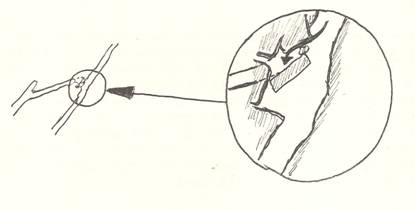
Browne’s Passage in Stoke I from the survey. All places where this can happen should be noted. One good trick for making a survey show
places like this, is to include an enlargement of any tricky bit. The actual enlargement can be drawn in down
the cave and shown like this:
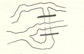
The next thing to decide from the existing survey is whether
or not various parts of the cave get in each other’s way too much – or whether
the surveyor has gone to the other extreme and separated them so much that it
is not easy to see what leads to what. For instance, I used to find it very difficult to see where the Dolphin
Pot route in Eastwater came out on the plan of the lower series. Where portions of the cave are detached to
make the survey clearer, it should be shown clearly that this has been
done. The sketch below should make this
point clear.
Having got the existing survey into a form so that the caver
can see and understand the cave, it is now necessary to visit all parts of the
cave and make notes of anything the caver might find useful. Here is a list of some of them:-
What tackle is necessary and
what, if any, provided?
What and where are the main obstacles?
How long might any given trip be expected to take?
How wet is the cave, or parts of it?
Are there any places worth photographing?
Are there any restrictions on lighting etc.?
Are any passages too small for average cavers?
Are there any special hazards (instability, ventilation, etc.)?
Is the cave, or parts of it, liable to flooding?
Are there any special techniques which have to be used?
Are some portions of the cave only accessible with diving equipment?
and so on. All this
sort of information should now be added to the survey – using words or
symbols. If symbols are used, there must
be a key to them but they should also be clear enough in meaning hardly to need
that key. There’s not much point in
giving a caver all this information in code! If in doubt, ask any fellow caver what he thinks a sign means – and if
he gets it wrong, or at least doesnt agree with it after you’ve told him –
scrap it and try again. In same cases,
don’t try at all. It’s just as easy to
write MUD SUMP alongside a mud sump than it is to invent some symbol for one,
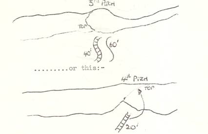
which the caver has to learn. Fixed and
portable tackle is fairly easy. Most
people would realize what the diagram at the top of the next page meant
.
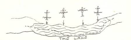
If a lake, stream or canal is shown on a survey, it is of
more interest to the caver to know how wet he is going to get than to be told
it is 320 feet above sea level. Something of the sort shown below might well do in such a case
..
And so on. One thing
that could be of use to a caver is not so much how long a particular passage is
(which he can get from the survey anyway) but how much time it will take to get
along. Time markers, representing 5
minutes of average caving time between them, could be the answer here. The sign I have suggested is as drawn below,
which is supposed to be a stylised drawing of an hour glass:-
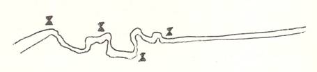
and is shown at appropriate intervals alongside every
passage in the cave. Thus, any proposed
trip can be estimated by adding up all the time markers along the chosen route.
There are many more types of useful information which can be
added in this way. The result would be a
survey which could be used by cavers fresh to the district to plan a trip in
advance. They would know what tackle they needed and where it was all to be
used. They would know what sections of
the cave could be visited normally, what bits needed diving equipment, what
passages were too small for the larger members of the party, whether it was
worth taking a camera down, and a lot of other useful information which is not
available on the present type of survey. I am sure that a survey laid out on these lines would get used
extensively, if it were done for a well visited cave like Swildons. If anyone is interested in having a go, I am
prepared to help as much, or as little, as required.
This article has gone on quite long enough, so I will not
describe any other new sort of survey, except to say that there is also a need
for a method of putting down useful information in a much smaller space than a
normal survey takes up. It is not easy
to spread out a large sheet of paper in a wet, constricted underground
place. However, if there is any interest
in this subject, and we get another month in which hardly anybody has sent in
anything for the B.B., I might describe possible methods in a further article.
S.J. Collins.
Round and About
A Monthly Miscellany,
by Wig
- M.R.O.
News. New callout arrangements
starting on SUNDAY, March 3rd 1974 for Mendip are the result of re-organisation
within the
requested that all emergency calls must be routed through their regional
control centre at Frome as from Sunday, 3rd March. To comply with this, all calls for cave
rescue must follow this procedure:-
DIAL 999 – Ask for POLICE –
Request police for CAVE RESCUE.
As a result of the phone change,
the M.R.O. notices will be changed and will also include the name of each cave
and the location of the nearest telephone. The police will require the following information:-
1. Name and address of caller.
2. Number and situation of telephone.
3. Nature of accident.
4. Name of cave.
5. Position in cave (if known)
6. Number of people in party.
7. Experience and condition of party.
The informant must then WAIT at
the phone until contacted by an M.R.O. Warden, who will give him instructions.
The police will ring wardens in
list order until one is located. The
police and the warden will then decide what action is necessary and further
action will be at the discretion of the warden and police.
- M.R.O.
Wardens. The present list is:-
Howard Kenny; Willie Stanton: Dave Irwin; Alan Thomas; Bob Craig; Roy
Bennett; Oliver Lloyd; Phil Davies; Jim Hanwell; Tim Reynolds; Fred
Davies; Brian Woodward; Pete Franklin; Brian Prewer; John Chapman; Frank
Frost and Harry Stanbury. - M.R.O.
Annual Report. There have been
15 rescues including alerts during the last year. Four of the six have been as a result of
falls, and 1973 might be described ‘The Year of the Fracture’. Two notable and ominous firsts have
occurred – the first abseiling accident in a Mendip cave and the first
badly injured patient requiring rescuing through a sump. These reflect the increase in abseiling
and prussicking by relatively inexperienced cavers. Whilst M.R.O. is strictly concerned with
cave rescue matters, we feel obliged to urge more thought in using these
new climbing aids and greater care regarding the composition of parties,
especially on long trips.
Sunday, 15th April 1973. Swildons Hole.
On returning from a trip beyond
sump I with two friends, David Dryden fell about 15 feet on attempting to climb
up the well in the Upper Series. He
broke the left tibia and fibula. In a
subsequent I thank you letter, Dryden writes
’the accident was cause mainly
through exhaustion brought about by not eating a substantial meal
beforehand. I had eaten something that
didnt agree with me the day before and was feeling the after effects that
day. Perhaps Ill know next time to
abandon the trip if I’m not in A.1. condition.’
Tuesday, 24th April,
1973. Swildons Hole.
A group of
at the bottom of Vicarage Pot. They had
abseiled down the pitch and pulled the rope down after them before realising
their mistake. This was an exact repeat
of the callout of 2.11.69. We hope that
the message has now been learned.
Monday, 24th June, 1973. Stoke
Lane Slocker.
A
was passed by a Cotham party on its way out. The latter, on surfacing, found the stream was rising rapidly due to a
thunderstorm. The W.C.C. party were
found making a rapid and safe exit before the stream rose to dangerous levels
at the entrance.
Saturday, 30th June,
1973. Goatchurch Cavern.
Yeaden, a member of a scout
party, on his first caving trip, fell and dislocated his shoulder in the Water
Chamber. As the medic could not return
the shoulder, his arm was strapped up and he was encouraged to get out under
his own steam.
Saturday, 30th June,
1973. Longwood Swallet.
Tress, one of an M.C.G. party
returning from a trip to August Hole, fell off the 10′ climb into the entrance
passages. He badly injured his jaw and
right cheek. He was given first aid and
persuaded to move out, largely on his own. A sit harness was found to be very useful in helping him up the narrow
entrance shaft.
Sunday, 15th July, 1973. St. Swithin’s Day Alert!
The meteorological office issued
a general warning that up to 2 inches of rain could fall on Mendip during the
after noon. Wells police notified
M.R.O. Local cavers were notified. In the event, the local fall was not as heavy
as first feared.
Sunday, 22nd July, 1973. Swildons Role.
A telephone call was received
direct from Mike Collins, caving sec. of M.N.R.C. informing that a friend was
stuck just beyond the little waterfall inside the entrance at the beginning of
the
coming from Swildons IV to show them the short way out so that they could get
out before their lights faded. This I
did, but Doug Stevens, who is rather stocky, got stuck but was adequately
protected and would not suffer from exposure. I left the cave to summon assistance on Priddy Green. The chaps went back to the rear of him via
the Old Grotto, and one directly to him so that he would not be alone too
long.’ Stephens was quickly freed by
members of the St. Albans C. C.
Saturday, 27th October. Sidcot Swallet.
A party of five from
lamps came to pieces. Fearing that they
might be gassed, three of them fled to raise the alarm, supposing that their
two companions might have been overcome. During the telephone conversation with M.R.O. the other two appeared.
THE SMALL QUANTITIES OF CARBIDE
GAS ARE UNLIKELY TO BE HARMFUL IN ROOMY CAVES, THOUGH QUITE LOW CONCENTRATIONS
ARE COMBUSTIBLE. DO NOT ATTEMPT TO SEAL
THE GAS IN, AS IT DETONATES ON COMPRESSION TO ABOUT TWO ATMOSPHERES.
Monday, 12th November,
1973. Swildons Hole.
A Cerberus S.S. party went down
the cave with the of abseiling down the old Forty on a double line. The first two members descended safely. However, when Graham Price began his abseil,
the loop flicked off the belay and he fell about 30 feet with the loose rope. Fortunately, he did not crash on those below
but landed on his left hip, sustaining a multiple fractured of the pelvis and a
not too serious internal rupture.
This potentially difficult rescue
went well on the whole though communications were delayed because the public
call box on Priddy Green was inoperative. It is believed that the fall occurred because the rope was dry and stiff
and so ‘stood up’ off the belay when the abseiler briefly supported his own
weight on the ledge below the lip of the pitch.
Saturday, 1st December,
1973. Eastwater Cavern.
An anxious friend phoned the
Wells police to report that his friends were overdue from a trip down the Twin
Verts. They were adequately
equipped. The party emerged from the cave
just as rescuers were being rounded up.
Thursday, 10th January,
1974. Sludge Pit.
Wells police phoned Jim Hanwell
at 2.40 a.m. reporting that a worried wife from
party that had gone down the cave the previous evening. Whilst the police were checking the
message was received from
reporting the safe return of the cavers. They had been delayed by a puncture. Surely, it would have been better had those involved troubled to contact
their homes to announce the delay and save needless worry and a rescue alert.
Saturday, 19th January,
1974. Swildons Hole.
Sith, a
student visiting Swildons II, fell at the 11 foot drop in the Old Approach
Passage. It was suspected that he had
fractured an ankle, although he had broken both tibia and fibula. This was the longest distance haul yet made
on Mendip, and the first serious injury in Swildons II. It is probably not without significance that
Smith was the only member of the
party without a wet suit, as well as being the least experienced caver. He had been caving five times previously,
including one much shorter trip in Swildons.
Saturday, 19th January,
1974. Swildons Hole.
Whilst engaged on the Swildons
Rescue, it was reported that a party had not confirmed their return from a trip
to Primrose Path. Two cavers were
detailed to reconnoitre the cave whilst the police tried to locate those
involved at their homes. The presence of
a rope at the pot gave cause for alarm. A member of the party was found safe and sound in his bed at his home in
Wells. Why make needless work by leaving
ropes underground or failing to remove outdated notices on blackboards?
Sunday, 20th January,
1974. General Alert.
The worried father of P. Sprules
contacted Frome police when his son failed to turn up after a days I caving at
2 a.m. A check of the list of those
helping underground in the Swildons rescue found him in a hauling team.
Sunday, 27th January, 1974.
Eastwater Cavern.
A party from the Harrow Moles
Club were reported about two and a half hours overdue during the evening. No official callout was received, so it
appears that they underestimated the duration of their trip. This is proving to be a common occurrence
with parties not familiar with the cave.
- Library
Notes. The latest publications
received include:-
Gloucester S.S. News sheet Nov,
Dec, Jan and Feb.
British Caver No 61.
D.B.S.S. Proceedings Vol.13,No 2.
Cerberus S.S. Newsletter No 34.
Bibliography on lava tube caves – Harter.
Supplement to above – Harter.
W.C.C. Journal No 151.
The Great Storms and Floods of July 1968 – W.C.C. Oce.
Pub. Series 1 number 2.
Belfry Bulletin. Volume 27 – two bound sets.
D.S.S. Journal No.114.
New Climbs 1968 – Ed.
donation.)
- Those
moaning letters. Recently a letter
appeared appealing for information happening ‘on top of the hill’ – I
wonder why this writer did not offer the B. B. his article that appeared
in the C.D.G. Newsletter on the interesting ‘overland I route from Wookey
4 to Wookey 9. I’m sure that this
would have been far more interesting to club members than my silly
notes! Nuff said!
Monthly Crossword Number 43.
|
1 |
|
2 |
|
3 |
|
4 |
|
5 |
|
|
|
|
|
|
|
6 |
|
|
|
7 |
|
|
|
|
|
|
|
|
|
|
|
|
|
8 |
9 |
|
10 |
|
|
11 |
12 |
|
13 |
|
|
|
14 |
15 |
|
|
16 |
17 |
|
18 |
|
19 |
|
|
|
20 |
|
|
|
21 |
|
|
|
|
|
22 |
|
|
|
|
|
|
|
|
|
|
|
23 |
|
|
|
|
|
|
Across:
1. All west for typical Mendip
cave. (7)
6. Youll
the day (Priddy Green Song). (3)
7. French stop in Cuthberts. (5)
8. Think on the right lines for this. (4)
11. and 14. Describes abortive dig?
(2,2)
16. These may hurt in a tight squeeze. (4)
21. Black hole? (5)
22. Green? (3)
23. Shorten this in G.B.. (7)
Down
1. Iron etc. causes this stal (5)
2. Form of nave underground. (4)
3. Part of Mendip cave name. (4)
4. Sump otherwise part. (4)
5. Resting place underground? (3)
9. Forward direction in cave. (2)
10. Initially, for example. (1,1)
12. Alternative which sounds like 22 across. (2)
13. Mendip cave. (1,1)
15. Coloured rift in Cuthberts. (5)
17. Dears curtailed is a notion. (4)
18. Crystalline substance, commonly. (4)
19. Fastener on wet suit. (4)
20. Mendip Hole. (3)
Solution to Last Months Crossword
|
|
F |
|
R |
|
|
|
C |
|
|
C |
O |
R |
A |
L |
|
M |
U |
D |
|
|
X |
|
T |
|
L |
|
T |
|
|
D |
E |
N |
|
L |
I |
G |
H |
T |
|
|
S |
|
D |
I |
P |
|
B |
|
|
C |
H |
E |
R |
T |
|
P |
E |
N |
|
|
O |
|
Y |
|
B |
|
R |
|
|
A |
L |
L |
|
F |
O |
R |
T |
Y |
|
|
E |
|
|
|
S |
|
S |
|
Club Committee
The Belfry,
Rd
Chairman S.J.
Collins
Minutes Sec G.
Members M. Bishop, D.J. Irwin, D. Stuckey, N.
Jago,
Officers of the Club
Honorary Secretary A.R
THOMAS, Allens House,
Barrows Lane
269
Honorary Treasurer B.
Clutton, Nr. Bristol.
Caving Secretary D.
STUCKEY,
Southville,
3. Tele :
Climbing Secretary N. JAGO,
Windmill Hill,
3
Hut Warden N.
TAYLOR, Whiddons, Chilcote,
Tacklemaster G.
WILTON-JONES, 17 Monkhams Drive, Watton, Thetford,
B.B. Editor S.J.
COLLINS, Lavender Cottage, Bishops Sutton, Nr. Bristol.
Tel
: CHEW MAGNA 2915
Honorary Librarian D.J
IRWIN, Townsend Cottage, Townsend, Priddy, Wells Som. Tel : PRIDDY 369
Publications Editor D.J
IRWIN As above
B.B. Postal B.