QUODCUMQUE FACIENDUM : NIMIS FACIEMUS
Contents
Editorial
In spite of any indications there may be to the contrary,
the editor would like to wish all members a Happy and a Prosperous New Year.
Shortages
Luckily, the threat of petrol rationing seems to have
receded, but other things are becoming either expensive or in short supply, and
the thing which is likely to affect the B. B. is the position of paper, which
is both!
A normal 24 page B.B. takes 3 reams (1,500 sheets) of paper
to produce. Not long ago, we were paying
60p per ream, but the paper we have had to buy in order to produce this one
(and it is the wrong sort of paper as well) has cost us £1.35 per ream. A move has already been made to economise by
combining pages 1 and 2 of the normal layout, and the only other compromise is
between wasting paper and giving members fair value for their
subscriptions. In the past 2 years, the
size of the B.B. has been kept constant every month. What we are suggesting now is that it might
be more sensible to see what has come in each month and make the size of the B.B.
correspond. Thus, this B.B. might well
turn out smaller, but future B.B.’s might not.
Incidentally, if any member can lay his or her hands on a
cheap supply of A4 paper suitable for litho printing, we would be extremely
grateful.
Ratification Time
As usual, at this time of the year, the committee have been
ratifying the last quota of members and, equally as usual, have been asking
themselves questions about the whole subject. On the one hand, nobody wants to refuse permanent membership without good
reason but on the other hand, the committee feel that ratification should not
be a ‘rubber stamp’ procedure.
One aspect which they have been considering this year is
that of groups of cavers who apply to join the B.E.C. The club is against formal affiliation
because it is felt that this is liable to produce ‘cliques’ so (in theory at
any rate) every prospective member joins as an individual.
Obviously, in a case where he has joined at the same time as
several of his friends, he is going to carry on caving with them – and the
dividing line between a small group acting and thinking as a separate entity
and one acting and thinking as part of the B.E.C. can never be sharply
drawn. The committee, however, would
like to think that members who already form such groups will make a real effort
to integrate themselves fully into the club.
That Motto
Having thought, in 1972, of a way to combine the letters
B.B. with the figures 72; it was with some relief that it was found possible to
do this with the figures 73 as well. However, 74 has proved beyond the skill of the editor to combine with
the letters B.B., and so we have a new heading. For those who might possibly be interested, the Latin motto has been
produced by the usual method of leaving out all the unnecessary words. The Romans did this because they objected to
having to carve more words on a piece of hard stone than they really needed
to. The motto is, of course, “Whatever
is worth doing, we will do it to excess” – a motto which has been that of
the B.E.C. for some years now and which might well be appropriate this year in
particular. The full sentence (with the
missing words in brackets) is Quodcumque (res) faciendum (est); nimis (illud)
faciemus and the translation again with the missing words in brackets is;
Whatever (thing is) fit to be done; we will do (that thing) to excess – which
is about as close as the Romans could have got towards the B.E.C. motto!
Alfie
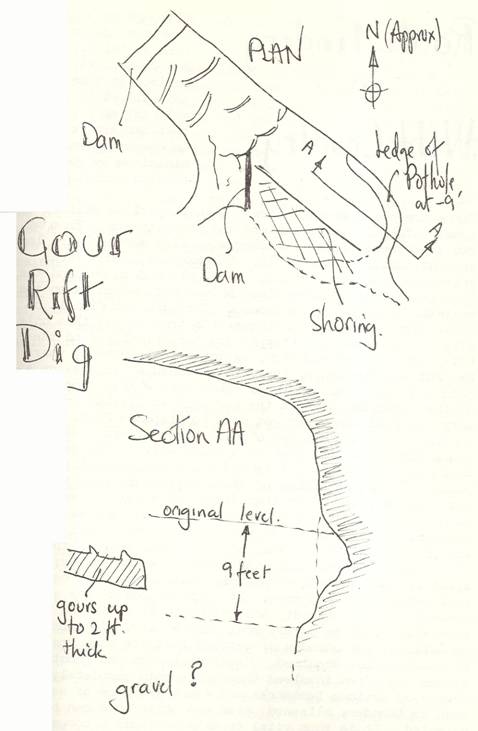
Gour Rift Dig
An account of this dig
in Cuthberts by Dave Irwin.
During the summer of 1972, through to the spring of 1973,
the Sunday Morning Digging Team attacked the end of the Gour Rift in an
abortive attempt to excavate a continuation of the Gour Rift.
For years, the end of the rift looked a tempting site for an
attack. In the early days of the
exploration of St. Cuthberts, the end had been investigated and the Bank Grill
entered, but this tight ascending passage gradually closed down. In 1957, the sump was passed by Balcombe and
Coase only to discover the further sump that was destined to become Sump 1 –
the original sump being then known as the Duck. In 1966, John Cornwell made the first attempt that seriously attracted
cavers to the end of the Gour Rift, but after a short series of digging
sessions, the site was abandoned. At
about the same time the
brothers made an attempt at the still un-entered hole at the top of the aven
above the Great Gour in an attempt to see if there was a high level passage
over the top of the Gour Rift.
Then, in 1966, the Tuesday Evening Digging Team came into
existence (Turner; Irwin; Craig; Woodward; Webster and several others) who
bashed the Dining Room dig for nearly three years and excavated a passage over
150 feet long that has how been proved to be the upstream end of the Whitsun
Series. Then came the major breakthrough
– almost by accident. By chance, the
terminal sump of St. Cuthberts was found to be empty of water in the autumn
drought of 1969. Secret digging sessions
(up to five in a week!) were made by Bennett; Craig et. al. and were rewarded
with the discovery of Cuthberts II. A
serious attempt to explore all the high level passages of two was made by
Bennett et al. in the following few years, together with an attempt to pass
Sump 2. All prospects of continuing the
cave in Two diminished.
During the same period as the Gour Rift Dig, then S.M.C.C.
dug at a point just downstream of Sump 1 at a point where the water was known
to soak away in dry weather. They
reached a depth of about fifteen feet before giving up.
At the same time, the S.M.D.T. attacked the end of Gour
Rift. The early digging sessions were
limited to the left hand wall. It was
here that Cornwell had dug in under an overhang that gave the appearance of
another passage running off the line of the rift by about fifteen degrees to
the east. The other point that was of
interest was the extreme end of the rift, where the tops of two phreatic arches
could be seen. These had been modified
by two chemical persuasion attempts a few years earlier (Irwin; Craig and
Searle in 1968 and Turner and Bennett in 1970) in an attempt to see clearly up
into the rift down which came the Bank Grill water. However, it became clear that a serious
digging attempt had to be made and so the dig became a bail-and-dig session. The whole floor was lowered and of course,
the lower the floor became, the larger the pool of water that had to be bailed
the following week in order that digging could be resumed. To prevent the water from flowing back
through the Duck, a small concrete dam was constructed. The construction of this dam eased the
bailing operation considerably, as the pool now needed about an hour and a half
to bail. As the fill began to be removed, large lumps of stal gouring were
uncovered. At first it was thought that
these were the remains of a series of descending gours that continued on from
the abrupt end of the series in the Gour Rift. However, this was not so and they were, in fact, isolated lumps which
had been deposited in the infill. At the
end, the phreatic arches were dug into and it was found that they were merely
the top of a four foot deep by foot wide phreatic hollow or pocket. Undeterred, the diggers continued lower to a
depth of about nine feet. It was at this
depth that the greatest blow occurred. A
rim of rock was uncovered which ran round the extreme end of the rift forming
the top of a pothole. This was probed
with iron rods to a depth of between five and six feet by a series of probes
that gradually increased the angle of attack so that an impression of the shape
of the wall under the infill could be obtained. Hopes of any sign of undercutting of the wall soon faded when it was
found that the walls were smooth and vertical. At this time, the digging sessions were becoming more of a bailing
operation than a dig. The bailing time
went up to about two hours. and digging time was correspondingly reduced.
To assist the bailing, several ideas were submitted, but the
most practical idea came from John Knops in the form of a water wheel. However, in practice, difficulties arose in
the form of binding bearings and other mechanical problems. During this time, large quantities of wood
were taken down the cave to shore up the right hand wall of infill to replace
the galvanised sheeting that held back the wall until the diggers undercut it
and the inevitable happened. When the
dig had been taken to its lowest point attention was transferred to the right
hand side, under the breccia in which is formed the Bank Grill pothole. The diggers dug in under the breccia, only to
find that a floor existed that sloped downwards, but back towards the
Duck. Probing at the Duck itself
revealed that the small arch which forms the Duck is, in fact, the top of a six
foot wide arch, largely buried in the infill.
However, for all the problems, we have learned a little
about the end of the rift that has attracted so much attention in the past
before work on the Burrington Atlas and on other activities – not least the
advent of winter combined to bring the dig to a grinding halt early in
1973. Anyone wishing to continue where
we left off is very welcome, but some form of pumping device is essential to
probe further than the S.M.D.T. were able to do. Perhaps after all the work that has been
carried out at the end of St. Cuthberts, the real way on will be found at the
bottom of the lake!
For the record, the regular diggers at the Gour Rift were
Doug Stuckey; Dave Irwin; Dave Turner; Chris Williams; John Rees; John Knops
and many others including tourist trippers.
( A sketch of the dig will be found on the next page.)
Caving Trips
The Caving Secretary asks ALL club members and guest leaders
to WRITE UP their trips in the appropriate log. Apart from this being required by the club rules and making a valuable
record, IT IS IN MEMBERS OWN INTEREST to write up trips, since money spent on
caving gear is related to the amount of use it is THOUGHT to get the wrong
impression is given without write-ups.
Route Finding in Wild Country
Although many of the practices described in this article…
by Bob Cross
will seem obvious to some cavers and fell walkers, it will act as
a reminder that dangers from exposure can easily be minimised by good route
finding techniques.
There are times when the craft I shall outline will be of
great value to both potholers and mountaineers. From my own experience, I can remember when club members were lost or
went adrift on the fells. For example,
about three years ago a party of B.E.C. cavers planned to descend the then
relatively unknown Black Shiver Pot, which is on the western flanks of
Ingleborough. They did not find it on
their first trip and I believe it’s true to say that only after three separate
attempts did they finally find the hole. On another occasion, again on Ingleborough, where Bar Pot was the venue,
the crew surfaced after dusk on a cold and rather misty night. They were wildly uncertain of the direction
back to the car park at Clapham and were very relieved when they got down to
Clapdale Farm. On yet another occasion,
a party of club bog-trotters took the wrong turning during mist on a ridge walk
in the Brecon Beacons, leaving their intended route and upsetting their plans. The consequences or these happenings were frustrating
and inconvenient rather than disastrous but, if we stop to consider a party of
cavers emerging cold and wet into freezing conditions and darkness from a
remote hole like Langcliffe Pot in Wharfedale or Pant Mawr in the little Neath
Valley; dropping into the wrong valley; getting split up and becoming
completely lost, they would be in real danger from exposure. It could happen on any winter weekend away
from Mendip and, although it may sound a little far-fetched, it is a very real
possibility. In climbing or walking, the
chances of getting lost are much greater if skill is not acquired. Great distances and remote places are often
involved through terrain completely devoid of obvious landmarks and where extremes
of weather such as thunder; blizzard; mist and white-outs can be expected. It is thus vital to make yourself a competent
navigator, and this is just as vital as being a good leader.
Wherever you go in the hills, you need a good map, a watch
and a compass. The need for a watch is
obvious, it helps you to keep to your schedule and, more important, you know
when the light will fade and you can make adjustments to suit. As far as maps are concerned, the most
detailed are the six inch Ordnance Survey maps, but the one inch covers more
ground in a sheet and the two and a half inch series probably represents the
best compromise. If you are on the hills
and you get lost, then any ground feature that can be recognised on the map
will be useful and enable you to get a compass bearing back to your intended
route. There are a variety of features
which we can use. Stream junctions
cairns, prominent boulders, trig. pillars, fences, stone walls etc. should all
enable you to pinpoint where you are. If
you periodically glance at your map and keep a note of your position then,
should the mist come down, you will already know approximately where you are
and be able to walk out on bearings accordingly.
If there are no prominent features, then you’ll have to be a
little more crafty. It is possible, if
you have a keen eye, to make use of the contour lines mid the vegetation
symbols. This is where the two and a
half inch map scores over the one inch series. If you look closely, you will see information of all sorts – walls,
footpaths, boundary stones, bench marks, depressions, bog, heather, scree etc.
all of which are as accurately positioned as the ‘harder’ detail.
Sometimes, even if you cannot see things, you can obtain
hints on their existence, e.g., the sound of running water, the sound of
traffic, chain saws working in a forestry plantation. I’ve even heard tell that if you hear a raven
caw-caw youre very likely near a crag.
Good co-ordination of eye and ear coupled with accurate
compass work can get you out of nearly any fix. Compasses come in all shapes, prices and qualities. The sort we want for moor land walking has a
base protractor. This is a Perspex
rectangle fitted with an arrow etched into the plastic base that runs through
the vertical axis of the compass needle. The SILVA range of compasses are this type. They enable accurate bearings from one point
to another to be taken from a map. I
will not go into their operation, as it is quite simple and will be explained
in the instructions for use which come with almost any compass. If you want to be really fastidious, then the
silva RANGER is the one. This has a
sighting vane and, on the most expensive model, a clinometer. A sighting vane can be useful on occasion,
e.g. for determining an astral fix, but that is outside the realm of this article. When you take bearings, add 80 west to allow
for magnetic variation. This matters
little over short distances, but the effect of ignoring it will give an
increasing error the further you go. If
for some reason, after walking for some distance on a bearing, you wish to
retrace your steps, set your compass to a back or reverse bearing. If the forward bearing is greater than 180,
subtract 180 from it and if it is less than 180, add 180 to it. When you’re in mist or darkness and cannot
see your target, you’ve got to set your compass to a bearing from the map and
make sure that you walk in a straight line. To do this, send a man ahead until he just begins to disappear, stop him
and get him to move right or left if necessary until he is dead in line with
your bearing. Now walk up to him and
keep repeating the process. If you are
alone, then try to find some object in the line of the bearing – perhaps a
boulder or a clump of grass and walk up to it.
If you are completely lost and are walking about in all
directions looking for a landmark, it is important to know just how far you are
walking. Count your paces as you
go. The average pace is about one metre. Down the side of the 2½ inch map are
alternate black and white steps. Each of
these is 100 metres.
Note where the wind is striking you. If it’s in your back and it comes round into
your face, you may be walking in a circle. However, if you have already taken precautions to avoid this, don’t
panic, as the wind often does strange things in the vicinity of crags and
ridges.
In summing up, there are many ways of establishing your
position and direction, and I hope that this article has been of some use,
especially to those who have not had much experience of walking across the
fells. I should like to end it by
recounting an experience that happened to me when I was walking in the
north. I took a pal in the Craven
Pothole Club up a fell side in the
known as Widdle Fell. The purpose of the
tramp was to examine a sink in the limestone that I had noted earlier in the
year. It was winter, and the snow lay
think and the mist was down below 1,200 feet. The sink was easily found, being in the bed of a steep, fast-flowing
stream, well marked on the map.
After inspecting the sink, we pushed on to the summit of
Great Knoutberry Hill (2,203′) just for the exercise. We had no compass and no torch, only a one
inch map. Visibility was very poor and
our only means of navigation was the map. We had about five hundred feet of very steep, rocky slope before we
reached the summit plateau. This proved
tiring but we reached the top quite quickly. Here, our stream was shown as coming out of a tarn – indeed its name was
Tarn Gill. Crossing the stream’s source
was shown the North/West Riding county boundary, running in a south westerly
direction straight to our goal and we hoped to find a feature that marked the
boundary. We soon found the tarn, and
sure enough, crossing the stream was a broken down stone wall. We followed this in a south westerly direction
for some distance to its end, but we were not yet on our summit. Closer inspection of the ground revealed a
line of spaced hardwood posts – the boundary posts! These were followed straight to the trig.
pillar on the summit. Here, we rested a
while – reflecting on our faultless navigation – when suddenly a voice
spoke. Na then, lads, bit chilly, ain’t
it? and we turned in disbelief to see a shepherd, dressed in cloth cap, baggy
cords and clogs and draped in an old stinking sack. At his feet ran a scraggy border collie. Hast tha seen any sheep behind’t
walls?” said he.
Notice
Owing to pressure of work, Nigel Jago is no longer able to
continue as Climbing Secretary and the Committee are therefore appealing for
volunteers for consideration as climbing Secretary.
Another Notice
Owing to the attempt to save paper by combining the first
two pages of each B.B. from now on, there is not normally any space for the
usual reminder that the opinions given in the B.B. are not necessarily those of
the club. An attempt will be made to put
a reminder in the B.B. to this effect from time to time where other space
permits.
SUBS for 1974 are now due!
Yes, we know that nothing will happen to any member until
the end of April. We know that some
members reckon that the next A.G.M. is the proper time to pay. We know that this is a tradition not to
bother too much about when you pay BUT if you dont pay now, how do we know
that you will or might later on? The
committee has to budget now and if it doesnt know how much is going to come
in, how can it decided how much it can spend? Point taken?
*****************************************
Members are advised NOT TO LEND OUT THEIR BELFRY KEYS. There have been instances of non-members
borrowing keys; taking out club tackle and NOT RETURNING IT. If YOU want YOUR tackle kept safety please
help.
Round and About
A Monthly Miscellany by Wig.
- Wednesday
evening diggers. Digging at
Hunters Hole has been switched to Manor Farm. Anyone interested should first phone Roy
Bennett for times etc. Tel No
- Chelms
Coombe Quarry. Rumour has it
that Nigel Taylor is involved in another cave discovery near box cave
further details next month.
- August/Longwood. In November, the P.C.G. pushed the end
of Reynolds Passage. The end of
this passage is fairly vague, as it depends on your size – and the more of
a midget you are the better. About
15 years or so ago Tony Knibbs of M.C.G. pushed well beyond the limits of
the passage as shown on the Rennie survey, to the head of a twenty foot
rift shaft. At this time, some bang
wire was seen hanging down the pitch. At about mid 1973, Fred Davies ended at the same point. In November 1973, Brian Lewarne of the
P.C.G. pushed to this pitch and oozed himself through the squeeze at its
top to reach the bottom where a stream entered. From the bottom, he pushed on again for
a short distance to reach the head of yet another shaft into which, at
some point down it, the main Longwood stream was seen to be entering. The depth of this shaft was estimated to
be about 50 feet, but the head was blocked by a boulder. Due to the very constricted nature, it
would seem that bang will have to be used.
- Porth-yr-Ogof. During mid 1973, a boy soldier lost his
life in Porth-yr-Ogof and at the request of the coroner, the police and
various interested bodies met on September 30th, 1973. The results of this meeting were
published by Frank Baguley in the C.C.C. news sheet, No 3 for 1973, as
follows ..The whole subject was dealt with in great detail, from the
precipitating cause of the accidents; the cave itself, the conduct of the
party and the preventative points of view. It was agreed that the police issue a statement giving the
recommendations of the meeting (to be vetted by Oliver Lloyd) which would
be circulated to all L.E.A.’s; armed forces; caving organisations; Youth
organisations, etc. The caving
organisations themselves were already dealing with the matter, and would
be making their own detailed recommendations in due course after
consultations. The main points of
the Brecon meeting are:-
1. It is impracticable to close the cave.
2. The Forestry will put up further detailed
notices.
3. Prevention and education are the main themes.
Should another rescue (recovery)
be required there, then there will be a one way traffic system involved.
It is still not possible to state
why the cave resurgence pool is so dangerous, as it does not appear to be so,
but with a history of five deaths, one cannot ignore the warnings. It is up to everyone – organisations and
individual cavers alike – to help in preventing further loss of life in this or
any other cave. Nobody can legislate for
the actions of the foolhardy.
- Coolites
again. I’ve not actually used
one, but for 44p it seems a good buy. Possibly a better buy (’cause it’s British – the Coolite is a
Yankee product) is what is called the Chemi-lite. This method comes as a small flat pack
about 3″ x it” x 1/32 thick. To use it, all one does is to tear off the top strip – and cor
blimey, it’s alight: This light
lasts for about an hour, but does have the advantage that it can be stuffed
into the crown of the helmet or, better still, stitched into the inside of
a wetsuit and ripped off when required. This item is being marketed by Rock Products,
in Descent. Early trials in
Swildons have proved its usefulness. A party came out from sump 1 on this light and stayed talking to
another party at the bottom of the Forty. The light was on its last legs when they reached the entrance. More details later, together with the
answers to questions such as; Are they completely safe? Are they toxic?
Are the burnt-out remains dangerous to animals? etc.
- Manor
Farm. The survey of the main
passage is now complete (see number 16).
- Limestone
and Caves of
the writer, who has not yet had time to read it from cover to cover. However, a scan through selected
chapters enables him to present this tentative review. This will be followed by a full review
in the February ‘Round and About’.
The first ten chapters deal with
the area as a whole, from geology; geomorphology of the caves; hydrology;
biospelaeology and archaeology. The
attempt has been made to summarise the present state of the art since the
publication of ‘British Caving’ in the 1950’s. The remaining chapters take each caving area in turn, with surface
topography; local geology, development of the caves and a general summary. The larger chapters are, as one might expect,
those dealing with the caves of Leck Fell, Casterton Fell, Kingsdale and Gaping
Gill. Fascinating reading is the general
summing up of this book and having only read a limited number of chapters; it
has already clarified the picture of those areas for me. The immediate disappointment soon
disappeared, but I had hoped that it would have used Tratman’s ‘Caves of Clare’
as a model – but when one considers the size of the subject, then I’m only full
of admiration and congratulate the many authors and the editor. See No 9 Nov. 1973 for details.
- Library
Additions (Yes, 27, due entirely to an editorial clang – Ed.)
Easier Climbs in the Avon Gorge,
South
Guide,1963)
B.E.C. Caving Log 1973 (9.1.73 – 14.10.73)
R.N. Mountaineering Club Bulletin Nos 148, 150, 153, 156, 159.
Mountain Craft Nos 73 and 79
The Climber Vol.5 Nos 1, 2, 3, 6, 7.
Vol.6 Nos 7, 8, 9.
Vol.9 Nos 4, 5, 6.
Vol 3 Nos 4, 5, 6, 7, 8.
Volume 4 complete.
Vol.5 Nos 1 2, 4, 5, 6, 7, 8,
9, 10.
Vol 6 Feb, June, July/Aug,
Sept/Oct, Nov.
Vol.7 Jan, Feb, May, Jun,
July/Aug, Sept/Oct.
Vol 8 1, 2, 3, Jul, Aug/Sep,
Oct/Nov.
Vol.9. Dec/Jan, Feb, Mar, Apr,
May, Jun, Jul, Sept.
Vol10.Dec/Jan, Feb, Mar, Apr,
May, Jun, Jul, Sep.
Volume 11. Complete
Vol. 12 No 1.
Group Newsletter No 53.
Mendip Caving Group News No 103.
EGONS Journal Nos 15, 16, 17.
Caving Club Newsletter Vol.2 No 1.
A copy of Tony Waltham’s book has been ordered for the library. See No 9 Nov. 1973 for details.
National Speleo Soc. (U.S.A.) have agreed to exchange and have sent:-
N.S.S. News Vol 30 Nos 6-12
Vol 31 Nos 1 -1 0
SWETCCC Spelio Vol 12 No 1 with supplement.
Occasional Publication No 3 –
Our many thanks to Milch of the
S.M.C.C. and to Keith (Sailor) Glossop for climbing publications and S.V.C.C.
newsletters.
Anyone turning out their
cupboards are welcome to throw any climbing or caving publications towards the
club library. All will be gratefully received.
The Catacombs of
Paris
The article by Colin Sage as
promised in the last B.B. (The editor
does occasional manage to find articles!)
Whilst I was in
in August, I decided to visit the catacombs. These are reached by taking the metro to Place Denfert Rochereau and
walking around the corner from the metro station. The catacombs are available for inspection
every Saturday at 2 p.m. throughout the summer and every other Saturday during
the rest of the year.
After paying two francs admission, one has the chance of
purchasing a candle for 60 centimes – and if you don’t have a torch, buy one,
there are no lights at all in the catacombs!
The catacombs are reached by descending a spiral staircase
consisting of 91 steps and going down sixty feet. This leads to a brick corridor underneath the
South side of the Denfert Rocherou square. This corridor, and also those that follow on from it all lead to the
ossuary. The good condition of the
roofing of these passages is necessary for the support of the buildings, public
roads and subterranean works (especially the metro!) By way of these passages, visitors find
themselves under the Avenue Rene Coty, which is then followed in a Southerly
direction the walls of the passages involved hold up the ancient aqueduct of
Arcueil.
Further on, one descends by a slightly sloping tunnel into
an area called ‘l’etage inferieur’. One
then notices an impressive reproduction sculptured in the rock, of the fortress
of Port Mahon – the principal town in
in the army of Louis XV during his periods of leave.
A little later on, we pass by the side of a well, cut into
the rock, the water of which is extremely limpid. It is called ‘Bain de Pied des Carriers’.
A reasonably steep slope leads back to ‘l’etage superieur’
and we arrive at the door of the ossuary. At the entrance one can read these lines from DeLille engraved in the
rock; Stop. Here is the empire of the dead.
Once the doorway has been passed, we go down a lot of
passages bordered on either side by millions of bones carefully stacked, all
coming from the ancient disused cemeteries of
displayed in the shapes of the cross and other decorative motifs of a macabre
quality. The origin of the bones is
pinpointed by plaques. After wandering
through different crypts, one comes across a sarcophagus, a stone altar, a
spring called simply ‘the fountain, of the Samaritan’ and various inscriptions
pondering philosophically over death and the fragility of human existence.
The ossuary collects together the bones of 5 or 6 million
people.
On leaving the ossuary, an inspection passage is passed
through, and one sees two immense domes which are natural and about thirty five
feet high. They are empty, but allow one
to think of the danger represented by such features to overlying buildings and
roads. The exit staircase which leads to
daylight on 36 Rue Remy-Dumoncel has 83 steps and is about fifty five feet in
depth.
The origin of the catacombs in
does not go back, as do those of
to the early Christian era., but only; to the end of the eighteenth
century. For nearly ten centuries there
existed in the first section of
a cemetery called ‘Des Innocents’ at a square which bore the same name. This cemetery, which received the remains of
many generations from some 20 parishes in the area, became one of the largest
centres of infection and threatened public health. Between 1725 and 1755, the inhabitants of the
neighbouring areas brought violent complaints which, for a long time, were fruitless. Finally, in 1780, most of the inhabitants –
terrified by the accidents which occurred in the cellars of the Rue de la
Lingerie, set up a committee towards the end of 1779, which became over 2,000
strong and petitioned the Lieutenant General Police by demonstrating the dangers to public healthy and safety
represented by this ‘centre of corruption’, in which the number of bodies
disposed had caused the ground level to become eight feet above the level of
surrounding ground and roads.
The evacuation of the cemetery was finally decided upon in
1785, and to dispose of the bones, the ancient subterranean stone passages
called ‘La Tombe Issoire’ were chosen. After having made these underground areas fit to receive the mortal
remains and carried out the preliminary works, the catacombs of the Tombe
Issoire were consecrated on the 7th of April 1786 and proclaimed the general
ossuary of the cemeteries of
begun from the Cemetery des Innocents to the catacombs.
After the destruction of the
all the tombs, inscriptions and crosses which were not claimed by the families
involved were also transferred to the Tombe Issoire.
The success of the operations prompted the administration to
extend them to other cemeteries in
and, from 1787 to 1814, a number of Parisian cemeteries were closed and the
bones sent to the ossuary, there to be arranged systematically according to
their cemetery.
Many burials of victims of the revolution (1788 to 1792)
were also made in the ossuary. Since
then, all human remains found in Parisian soil have been placed in the
catacombs.
The Cyalume
Some further news on chemical lighting.
The Dorset Caving Group, after reading last month’s
description of the Coolite, kindly sent the editor of the B.B. one of their
chemical lights for test and comment. or
which I should like to express our thanks in the B. B. (and also when I write
to them more fully).
This light is made by the Cyanamid Corporation of
the trade name of CYALUME. In spite of
the fact that the one I was sent was labelled ‘use before Jan ’74’ it performed
extremely well. For the first four
hours, it gave a good light, of the sort that no real caver could possibly
complain about in an emergency. How
many light hours after ignition? it was
still enough to grope out of a cave with, and it would have been possible (in a
dim enough light) to have recognised it if used as a marker some 48 hours after
starting.
Like Dave Irwin, I too am chasing up the answer to the
questions involving toxicity etc., and I hope that an article will appear in a
later B, B. this year, from one or other of the sources we now have in hand. One theory which I have heard is that these
devices are in actual fact artificial glow-worms, since it is suggested that
they use the same method of illumination, which in the case of the glow-worm is
known to involve the mixing of two chemicals (originally dubbed Luciferin and
luciferase)
The Cyalume is, like the Coolite, a plastic tube which, on
being bent, breaks a glass ampoule which float a in liquid ‘A’ and contains
liquid ‘B’. The answer to using them
would appear to be best met by two terry clips fixed to the helmet, between
which the light can be clipped when in use. This modification to a helmet is cheap and simple to do. It might just pay to keep the tube inside a piece
of copper pipe with two corks to ensure that a nasty thrutch in a cave does not
set it off – but this is a refinement.
As a preliminary finding, it would seem not too expensive to
keep one of these as an emergency light, but until we know more about them,
please be careful about disposal.
Monthly Crossword Number 42.
|
|
1 |
|
2 |
|
|
|
3 |
|
|
4 |
|
|
|
|
|
5 |
|
|
|
|
|
|
|
|
6 |
|
|
|
|
7 |
|
|
|
8 |
|
|
|
|
|
|
|
|
9 |
|
|
|
|
|
|
10 |
|
|
|
|
|
11 |
|
|
|
|
|
|
|
|
12 |
|
|
|
|
13 |
|
|
|
14 |
|
|
|
|
|
|
|
|
|
|
|
|
|
|
Across:
4. Cuthberts series you might
expect to find under water. (5)
5. Cuthberts Hall. (3)
7. Part of the name of a Burrington cave. (3)
8. Not heavy but essential. (35
9. This clue should strike a caver. (3)
10. Type of rock. (5)
11. Mendip hill. (3)
13. The lot found in mud hall. (3)
14. Was in Swildons. (3)
Down
1. O flex shoe on Mendip (4,4)
2. Hilliers hall makes Cuthberts run (3)
3. B.C. Shutter on Mendip. (9)
6. Edge of a pot. (3)
8. 8 across is when in a cave. (3)
(3)
12. Mendip Swallet. (3)
Solution to Last Months Crossword
|
P |
O |
T |
|
B |
E |
C |
|
O |
|
|
R |
O |
P |
E |
|
O |
L |
D |
|
W |
E |
|
R |
|
S |
|
A |
D |
|
E |
|
S |
I |
D |
C |
O |
T |
|
|
T |
A |
|
D |
|
A |
|
E |
G |
|
|
B |
U |
D |
D |
L |
E |
|
A |
|
M |
E |
|
Y |
|
E |
|
U |
P |
|
A |
D |
D |
|
S |
S |
S |
S |
|
|
P |
|
O |
N |
E |
|
T |
E |
N |
The Belfry,
Rd
Club Committee
Chairman S.J.
Collins
Minutes Sec To be
appointed
Members M. Bishop, D.J. Irwin, D. Stuckey, N. Jago, N. Taylor, A.R.
Thomas, B. Wilton, G. Wilton-Jones
Officers of the Club
Honorary Secretary A.R
THOMAS, Allens House,
Barrows Lane
269
Honorary Treasurer B.
Clutton, Nr. Bristol.
Caving Secretary D.
STUCKEY,
Southville,
3. Tele :
Climbing Secretary N. JAGO,
Windmill Hill,
3
Hut Warden N.
TAYLOR, Whiddons, Chilcote,
Tacklemaster G.
WILTON-JONES, 17 Monkhams Drive, Watton, Thetford,
B.B. Editor S.J.
COLLINS, Lavender Cottage, Bishops Sutton, Nr. Bristol.
Tel
: CHEW MAGNA 2915
Honorary Librarian D.J
IRWIN, Townsend Cottage, Townsend, Priddy, Wells Som. Tel : PRIDDY 369
Publications Editor D.J
IRWIN As above
B.B. Postal B.