Contents
- 1
- 2 Editors Notes
- 3
- 4 The Years Climbing
- 5
- 6 Personal
- 7 Caving Meet
- 8
- 9 A Trip to the Falls
- 10
- 11 Caving Meets
- 12 Culture
- 13 Speleological Fallout.
- 14
- 15
- 16
- 17 Austria 1965
- 18
- 19 Callan Pot
- 20 B.E.C. Caving Report Number 11.
- 21
- 22 An Elementary Consideration of Heat Losses from Streams of Water in Caves
- 23 Book Review
- 24
- 25 Second Report of Roman Mine
- 26
- 27 Photo Essay
- 28 Austria
- 29 Postscript
Editors Notes
It is custom at this time of year to endeavour to produce a
B.B. of somewhat larger than normal size, and we are pleased to be equalling,
and in some way exceeding the record this year. A forty page B.B. has, in fact, appeared before, but not a forty page
B.B. containing nothing but reading matter as distinct from the usual four or
five pages of names and addresses which have been until now included in the
Christmas B.B.
It is also heartening to note that this year the main
problem has been now to find room for all the articles which have been
submitted. We have a good variety as
well and something to suit most tastes. A climbing article; travel; a little comic relief; the write up on the
official club trip to the Dachstein area last summer; a scientific article and
a caving/archaeological article as well as several smaller items.
This B.B. is also being used to experiment with a new type
and grade of paper. If this proves a
success, we hope to go over entirely to this paper for the 1966 B.B. which will
be the twentieth volume. There are other
improvements coming, but in line with our new policy of not winding the neck
out, northing more will be said in anticipation.
It remains to wish all club members, all our readers and all
cavers everywhere
.
A Very Happy
Christmas
Alfie
The Years Climbing
The proper way to present this would be to have the
Mountaineering Year illustrated, because the greatest impact from this years
activity was visual. There was enough
good weather to give fine views and walks and the opportunity to climb
satisfying routes. Many trips were also
made other than those described in this summary which is concerned with club
meets.
The end of January brought the usual crop of enthusiast to
satisfying snow. It wasnt quite like
that. Enough snow lay around to
encourage a party to look for a suitable gully below Glyder Fawr but the soft
state of the snow caused attention to be concentrated instead on Bennett,
plodding around on a pair of skis (on his shoulders) and Kingston glissading
(on his face). Phils glissade was a
gracefully executed classic as he successively threw away his ice axe and then
finished in a flurry of head rolls. Is
nothing too difficult for
buying boots in
Tryfan was ascended en masse the next day. A perfect day. Part way Eddie Welch and Mark James left the
main party and climbed the North Buttress. The others, Ann Farrington, Mo Marriott,
Kangy went on up the North Ridge. Bright
sun with blue skies accentuated by white snow and a foreground of clean rough
rock satiated the eye. Meanwhile Titas
practiced glacier lassitude in the van.
A
mid April. Base camp was, very
pleasantly, by the river at the Biblins. Notably, two interesting routes, not to be found in the guide, were made
by Roy Bennett on the upstream Seven Sisters Pinnacle. The wetness set in on Sunday and the party,
after glooping at a few climbs and holes, squelched home.
During Whitsun, the opportunity was taken to combine a
Caving and Climbing meet. Climbing was
mostly on the Dewerstone near
cavers were introduced to the delights of granite big jugs but not too
many. Zot lost his teeth on a climb. Tho that wath my Zot wath thaying Theckthy
tho thurlily. Climbs were also done on
the tors and as a grand finale a large party walked in pleasant weather via
Wistmans Wood to the Beardown Man.
Conditions for the meet on the 17th 18th July were
extremely fine and this resulted in a multiplicity of climbs being done. This was the first attempt at a combined meet
with the Insmen Climbing Club. On
Saturday, the Insmen set off very early for the East Face of Tryfan, Grooved
Arête in particular. The B.E.C., nine
strong, made for the less crowded precincts of the Carnddau climb on
Crag-yr-Isfa where Roy Bennett and Mark James did Pinnacle Wall whilst Steve Tuck,
Kangy, Eddie Welch, Bob Sell, Flicka Nash and Phil Derrick struggled up the
moss covered Avalanche Gully to reach and climb South Buttress, which has two
interesting pitches at the start. We
rendezvoused at the summit. The majority
then followed a most interesting and enjoyable walk to the top of Carnedd
Llewellyn and thence to Carnedd Dafydd, Pen-yr-Olwen, Rhaedir Ogwen and back
along the road and track to the Gweren-y-gof Isaf campsite. The distance covered was twelve miles and
some discomfort was caused by lack of water on the Carneddau.
The party split up soon after Carnedd Llewellyn as Kangy and
Mark descended to the bottom of the Black Laddeer, Ysgolion Duon, Jacobs
Ladder which could not be identified as it was getting late, they ascended
Western Gully a first class evenly graded V. Diff. The Sunday was another remarkably beautiful
day and the B.E.C. and the Insmen combined to swarm all over Dinas
Cromlech. Here novice was encouraged by
tiger and tiger was encouraged by warm dry rock and Flying Buttress, Parchment
Passage,
Crawl, Horsemans, Spiral Stairs, Holly Buttress and Sabre Cut provided
enjoyable finishes to a marvellous two days.
Tradition is perhaps to be respected, but Williams Isaf is
really getting too noisy on Friday nights. On the October meet, seizing a break in the weather after a sleepless
night, Mark James and Kangy climbed the Main Wall of Cryn Las most of which was
suffering from leaks. A high spot in the
climb was the great cheer from members of the Climbers Club that greeted the
peg hammered in by a Brummy and left at the stance before the crux. The cautious lad who won applause later
managed to find room for about a dozen runners on that pitch and he still had
a dozen left!
Main Wall was followed by Rectory Chimney in an attempt to
join the bonnets, Tuck, Welch, Ron Pepper and Phil Derrick who had climbed the
Parsons Nose. Sunday dawned bright and
the combined party made individual attempts on Moel Siabod. Pepper, James and Kangy climbed several
hundred feet of slabs to the right of the Great gully in the East Face. The climb is worth identifying because it is
not in the literature. It starts at the
short chimney in the lower left corner of the sweep of slabby rock which is the
face to the right of the Great Gully. The game is then to stay close to the left edge. The others who had enjoyed views from the
the summit.
The last meet of note was in the Brecon Beacons in
November. Accommodation was arranged at
the Storey Arms for a dozen and from there a walk was planned to Pen y Fan and
Pen y Fawr. This is an easy route in
sunshine but with the visibility down to twenty yards, compass work was
required. The rain ceased as the party
gained height, but after contouring round the hill and gaining the crest of the
ridge near the monument, the full blast of the wind was felt. Movement required considerable effort and
hair rapidly acquired an armour of tiny crystals. The flat summit was gained, a photograph was
taken and plans to descend via another ridge were abandoned in order to get out
of the wind. More sheltered slopes were
followed to the valley. High spirits
wrestled and rolled down the hill to the roaring fire at the Storey Arms. The supper was excellent and plenty of
it. Afterwards a pub was found and the
rest of the evening passed in quiet contented mood as tired muscles
relaxed. Two more members turned up for
the Sunday walk and after a rather disappointing breakfast, the meet started
from Crickhowell across the
Again the wind was fierce with a temperature lower than
Saturdays, but every now and then the sun broke through. Unlike Pen y Fan, there is no escape from the
wind on the smooth plateau-like ridges of the
Mountains
ground was firm and frozen, the walking was invigorating. The views were superb with only the walkers
to appreciate them.
On the descent, the party split into small; groups chatting
together something not possible on the ridge, and walked down a wide grassy
path to reach the cars.
January, April, June, July, October and November. These have been the popular times for meets
and the 1966 meets will follow this pattern. The need has arisen to cater for the mountaineering novice so a
deliberate efforts will be made to formulate a new programme. This should cover ability and weather
conditions to enable everyone to get the most out of that most precious
experience, the climbing weekend. Thanks
are due to the efforts that Roy Bennett has made to organise and arrange
accommodation for the meets and also to climb with newcomers.
Compiled by Kangy during December
from reports by Phil Kingston, Eddy Welch, Ron Pepper and Roy Bennett.
Personal
Whilst still on the subject of climbing, we must offer our
congratulations to Simon Davies, aged six, who seconded Fred and Kangy on
Knights Climb at Cheddar recently.
Caving Meet
by John Manchip.
At various times between mid-day and halfway though the
afternoon, parties left the Belfry to visit
and Axbridge Ochre Cavern. Joan Bennett,
Eddie Welch, Phil, Bob Bagshaw and myself set off for the Ochre Mine at about
12.30.
Following Dave Irwins directions for an easy route to the
entrance left us wandering around the hill some two hundred yards to the west
of the mine. At this point Joan left us
to walk to
beautiful. However, we had the good
fortune to meet a local a little later, who pointed out the way.
Entering the mine about two oclock, we went up to the cave
and explored this in a few minutes, then spent another ten looking for
more. Descending to the mined section
and walking to the end, we observed that the mining consisted of scooping out
the ochre from a natural rift, no rock cutting being necessary. After fighting our way out of the cave, we
changed and left for Coral.
Arriving there at dusk, we met Dave Irwins party just going
down and so formed a party with them. An
interesting time was spent in the cave examining the formations in the coral,
e.g. tins cemented to the wall by flow two bicycle frames, one milk churn and
much assorted ironmongery. Sampling the
delights of the pitch again, we returned to the Belfry for a meal and a wash
a fine end to an enjoyable day.
A Trip to the Falls
Our next article is rather topical
at present although strictly non-political! Seriously, we thought that a travel article might help to dispel the
British winter
.
by George Honey.
It was one of those long hot summer days you get in
set out from Devon, a little town on the
and we had an easy drive to
some seventy miles away. Of course, we
reached the town just as everybody was coming out from work, but we got through
without too much delay. From
about sixty miles across the flat, high veld plain. Here and there we passed small villages and
farms, but for most of the way there was just a view of miles of dry grass and
small thorn trees bush land. However,
the Zephyr I was driving simply ate up the miles and we reached Warmbad just as
it was getting dark. We had a quick
coffee there to let it get properly dark (it takes about fifteen minutes in
those parts) and then on to the border at
this was not to be as a line of cars greeted us as we drove to the custom
post. The border closed at 8
oclock. After some nosh at the local
café, we did as everybody else and went to sleep in the car. At first light, everybody was up and we were
soon through customs and into
modern, well developed town with lots of new bungalows in the suburbs. After some food at a road house (which was a
copy of a medieval castle) we decided to try to reach the falls that night, so
we took to the road again and soon the bush closed in and the road became two
strips of asphalt each about a yard wide. It was surprisingly easy to drive on except when you wanted to pass
somebody. Fortunately we only met one
other car in the whole 230 mile trip, so all was well. We then came onto a new highway, and we were driving
along in fine style when we passed the wrecks of two new cars. We were later to learn that these had hit, or
had been hit, by a herd of Kulu a lesson that wild life was very close and to
be reckoned with.
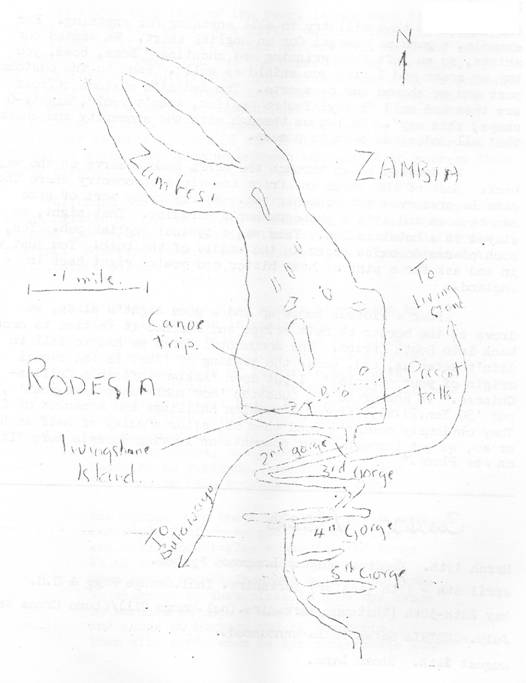
We reached the falls just as it was getting dark. Its easy to see them from about five miles
away, as there is a cloud over them in otherwise a clear sky. When we got to
so full that it meant another night in the car. However, its quite warm there and there is a good rest camp where one
can get a shower and a shave, so its quite pleasant really. There is a superb restaurant where the food
is excellent and quite cheap which almost overlooks the falls.
The next day, we were proper weegees and took many
pictures. The falls are more than a mile
across, as the
falls 350 feet into the gorge below. The
gorge itself is quite narrow only two hundred yards or so but there are a
number of cross gorges where the falls used to be. As the river finds a new cross fault in the
rock, the falls move suddenly upstream. They are now having their fifth go! The map on the next page will give you some idea of the situation.
There are some interesting routes to do. One the Knife Edge is about three feet
wide and you get very wet in the process. A canoe trip to
still if you miss it. On the west side
of the falls, the incessant spray causes a tropical rain forest to grow. The guidebook advises you to take a raincoat,
but we had a cheap shower when we walked through it. After this free bath, we walked back to the
rest camp and had a long talk with the owner of an art shop. His wife did the most beautiful paintings of
native faces and places.
That night we stayed in
charming coloured gent at the frontier. The waters of the
wonderfully clear above the falls and we had a good wash in them although
there are supposed to be crocs and hippos about. Then to a native stall where we did battle
with the vendors. They will try to sell
you anything. For example, a genuine
assegai for an English shirts. We wanted
our shirts, so we left them grinning and shouting, Boss, boss, you buy my
spear and I will give you a shield as well. Back to the customs post and we showed our passports. The Rhodesian customs officer saw them and
said, I say! Youre English, arent
you?, Righty O chaps, this way. He
let us through with the sincerity and charm that all Rhodesians seem to posses.
We decided to go through the Wanki Game Reserve on the way
back. Most of the parks in
and concentrated. Nearly every sort of
game can be seen and its a photographers paradise. That night, we stayed in an hotel in
Det. This was a typical English
pub. Yes, such places do exist right in
the middle of the bush! You just walk in
and ask for a pint of best bitter and youre right back in
After a riotous booze up and a good nights sleep, we drove
to the border at
deter us, and, under the heading of What is the racial origin of your
parents? I put down Eskimo-African & Chilean- Chinese. In answer to the question How much fund have
you? I put 50 Yen, 2d.m, 4 Kroner, 2 Zambian Shillings and a packet of
fags. They obviously couldnt read them
as, after a delay of half an hour or so we got through. Our comments on leaving
Its an
Caving Meets
March 13th. Mendip. August/Longwood System.
April 8th 11th (Easter)
May 28th 30th (Whitsun)
July.
August 24th. Stoke Lane.
Culture
At about this time of the year, it has been the endeavour of
the B.B. to try to bring a little culture into the otherwise drab lives of its
readers. Older members will no doubt
remember the Rubaiyat of Omar Obbs and the Norse Saga of Berewulf. It is therefore with justifiable pride that
we were able to announce this year that our researches into the depth of
English Lit. have unearthed a hitherto unpublished portion of Chaucers
Canterbury Tales. This fragment is
thought by scholars to be an earlier version of part of the Prologue which
Chaucer was later forced to abandon by persons unknown who wished to suppress this
early reference to the B.E.C.
Although the more difficult aspects of the spelling and
pronunciation of the text have been removed (final es are not sounded for
example) we realise that it still makes difficult reading. However, it must be remembered that you
cant not ave instant culture
.
A cavynge ladde ther was, a
stryplynge he
Yit wel y-versde in spelyologye.
A lampe hadde he of bras upon hys hatte
Y-broyderde on hys cloke ther was a batte.
Hys bootes grete of lethir on hys feete
Al dubbynde wer, and sette with nayls complete.
Around hys wayst hadde he a nylone lyne
And from thys gerful hyng a karabyne.
As wel coude he pleye on a giterne
In al Meydeepe, nas brewhouse ne taverne
Hadde he ne visitede, and dronk hys wyn
Til dun he fel, y-dronken lyk a swyn.
Now turned oure hoste unto thys caver mery
And seyde Before we goe to Caunterbury
And tells oure tayles wonderful and longe
We al woude lyk from you a mery songe.
Thys caver then bethoughte himself to singe
Ne wishynge in that plaas to she whys rynge
So strucke of herynge and of leccherie
Then alle setde when he hys songe hadde sunge
He hath a rotten, fowle and yvel tunge.
We al mst leewe thys cavynge ladde byhynde
For eke he hath a wikkyd twystede mynde.
Now by Seynt Cuthberd! spake thatte caver bolde,
Righte ribalde tayles will ye al hawe tolde
Upon youre wiage. If I go alonge
Wyth you we will have many a Hunters songe
And mayk oure way by ridge-walks on the doune
Thatte runs to Caunterbury from
toune.
Oure Clymbynge Secce will wryte, for al to see,
A notys of our tryppe in the B.B.
And diverse other cavers joyne oure ranks.
Agrede! seyed every oon, You have oure thankes
And, if you come to Caunterbury, we
Wil al applye to joyne the B.E.C.
Editors
Note: It seems doubtful whether any
other cavynge sorry, caving club can claim such an early reference in English
Literature!
Speleological Fallout.
In return for the use which cavers make of aluminium alloys
developed for aircraft, cavers have been able to contribute towards the safety
of the
supersonic airliner.
Lightweight caving ladders were lent by the Bristol
Exploration Club to the Filton Division of the British Aircraft Corporation to
help in evaluating escape techniques. From the ground, the
wings are twenty feet up. Escape hatches
are positioned over the wings and this means that some controlled method of
descent which can be stored on the aircraft is essential. The ladders were tried as a possibility
because they are light, strong and, strange though this may seem to a caver,
able to resist heat.
R.S. King.
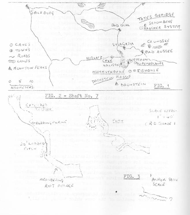
Austria
1965
by Dave Irwin and Joan
and Roy Bennett.
The Following article is not intended to be a day to day
report of the various activities, but a general description of the visit to the
Dachstein Plateau and the caves visited under the fine guidance of Helmuth
Planer and Wolgang Hvemer.
The reconnaissance of the Dachstein Plateau produced several
finds none being extensive which probably are already known to the
Austrians.
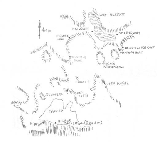
The notes made by various members of the party showed that
most of the caves found were shafts, all in the immediate area of the Simony
Hutte and the Wiesberghaus (1½ hrs. from the Simony Hutte). The average depth of the shafts was 40ft.
ending in stone of clay chokes. There
was one exception; Shaft No.7 was bottomed at a depth of over 100ft. The shafts appeared to be mainly formed by
vadose action, whereas the short caves rarely over 6ft. long were mainly
phreatic.
The systems noted were immature in appearance but the number
of holes in the karts indicated that the lower reaches of limestone must have
considerable quantities of water collecting to form large cave systems.
The first days search involved two parties. Party 1 searched along the large doline and
scree slopes of the Tauben Kogel and found several shafts (Area C on
Fig.4). At the base of the Tauben Kogel
a very large phreatic tube was inspected but was found to slope upwards and
terminated in a rift that could not be entered.
The second party inspected that smaller doline (Area A on
Fig.4) to the west of the Simony Hutte and found several shafts (all choked at
about 20 Feet) and short caves. One of
the caves contained a very fine ice grotto made up of crystal clear ice
pendants and ice curtains. There
appeared to be little melting taking place although the air temperature outside
was probably 65OF. A snow block at the
entrance was probably the agent cooling the air entering the little system.
Shaft No.7 was visited the next day and proved to be over
100ft. total depth (area B Fig.4). The
shaft, on inspection, was some 20ft. deep with a steeply sloping bedding plane
inclined at 40O heading approx. south west. This led to a rift passage that ended in a 20ft. pitch into a bell
shaped chamber. From this chamber a
meandering rift led to a second and final chamber. (See Fig.2).
Later that day a party of 5, undeterred by the pouring rain,
had a further look for sinks along the path leading to the Dachstein
Ridge. It had been reported by a member
of the party that he had noted a particular active sink. Several sink holes were found, and
considerable quantities of water were seen to be poring into them. It was extremely interesting to watch the
water flowing down the steeply vadose trenches all leading to larger trenches,
with the water finally sinking in small shafts leading under snow fields but
never appearing at their lower edges.
On the second day a group visited the series of large
dolines north of the Wiesberghaus. The
intention was to locate an ice cave reputed to be finer than the
but they met with no success (Area D Fig.4).
However, many entrances were found including a 35ft. deep
double shaft that ended in a tight extension at the bottom. It soon became clear to the party that this
level was more promising then the higher levels near the glacier but, time and
descending cloud made further inspection inadvisable.
During discussions that followed it was generally felt that
we needed more information about the area, and that the likelihood of finds
were much better at the lower levels near the heads, or on the sides of the
deep cut valleys. The higher regions
nearer the retreating glacier contained only small holes as those found on the
small conical peak called Schoberl, lying south west of the Simony Hutte.
A small cave in the
of this was reached by climbing. It
consisted of a small chamber with an inaccessible chimney in the roof. Other holes were noted in the vicinity, but
did not go. No draughts were noticed in
any of these caves.
As a change from looking at holes a trip was taken up the
local peak, the Hohe Dachstein, 3004m (nearly 10,000ft.) high. This was quite easy under the prevailing
conditions and comprised a walk across a very un-crevassed glacier leading up
to the rock wall of the peak. This should
have made a pleasant finish to the climb, but was entire ruined by the vast
amount of ironmongery, chains, stemples, etc. The party did not linger on the top because of the inclement
weather. Members enjoyed some good
glissading on the way down.
One cave in particular found near the
was of interest as it was a small phreatic tube. Further down form the peak two small caves in
the north wall of the Neiderer Dachstein were climbed up to. The east one had a chimney entrance full of
vertical soft snow. This could be
climbed to a small chamber with ice on the walls and an inaccessible chimney in
the roof. The west one was a small
chamber containing old snow, with no extensions. Further down the same ridge there were two
rather inaccessible and unpromising looking holes. Lower still in the east face of the Neiderer
Kreuse there was a much larger hole which was not visited. After leaving the glacier, the path passed
east of, and close to, another hole which would have been worth another
look. Nearing the hut again, a small
shaft on the same side of the path as descended for about 12ft. There was an estimated 30 feet to go to what
appeared to be a small chamber or passage. (See Fig.3).
From the notes made by various members there was general
agreement that if parties were to return to this area then a terrific amount of
digging would be required to get into anything big and that the lower reaches
would pay bigger dividends.
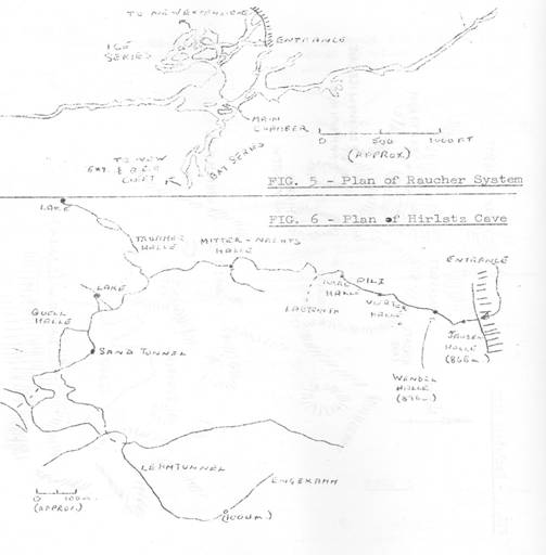
HIRLATZHOHLE (alternatively Hierlatzhohle) (Fig.5).
Following a 9 oclock start (central European time not
Belfry time) a short car drive led to the bottom of a heavily wooded scree
slope at the base of the high and impressive Hirlats Wall. Our path to the cave entrance involved a
longish (so we thought) climb up the scree slope. It was not long before certain members,
sweating from head to foot, were swearing that they would never smoke another
cigarette! A half hour later, after
numerous stops, we arrived at the cave entrance with our guides Helmuth Planer
and Wolfgang Hvemer looking as cool as when they left the cars.
The cave entrance was some 25 feet above the floor level and
reached by a fixed iron ladder. The
entrance was locked by a heavy iron gate, the key for it having been obtained
from the proprietor of the Café Bilz at Halstatt. Soon everybody was ready, feeling more that
we should go down into the valley and recuperate from the exhausting climb
than face a long caving trip.
As we entered the cave, a fresh blast of air greeted us
becoming stronger as we approached the twilight zone. Here the roof dropped to a low bedding plane
forcing one to grovel and manoeuvre over planks of wood thus keeping out of the
cold pool of water on the right hand side. Our guides were quite surprised to find that the entrance was not still
iced up. At this point the air moving
out of the cave was almost gale force, blowing out the lamps and creating a
miniature sea storm on the surface of the pool. After a seemingly endless delay of passing kit through the bedding plane
we warmed up in a fair sized chamber with a mud covered floor. From here a long stretch of narrow passage
with a series of blind potholes in the floor led to several kilometres of sandy
passage, broken frequently by potholes up to 40ft. down. Suddenly the passage became blocked by a
boulder choke and a bypass through small sandy passages led to an enormous
passage over a kilometre in length. The
floor, strewn with boulders of varying sizes, was about 20 30ft. wide and the
roof rarely dropping below 20 25ft. in height. A fork in the passage terminated this large
section. To the right our way was
barred by a large lake, but we were informed that this was quite short and a
passage continued for quite some way the other side. The left passage involved a traverse
around a deep vadose trench, with an active stream feeding the lake. After a few yards the sandy type of passage
continued until we reached a camp site. Here a well earned smoke break was taken. It soon became apparent that the cave was
generally colder than the average English cave. The ground was extremely cold to the touch, and the cave temperature
varied between 3°C and 6°C in comparison with the average
English temperature of 10°C.
Leaving the camp site we continued to the last section of
the cave. A fixed wooden ladder led to a
high level passage, at first being quite small, but soon returning to the
average size passage of some 10ft. wide. This last section was particularly interesting. The fill was a fine lime dust that was
apparently not brought into the cave but was said to be formed from the
continuous break-down of rock within the system. Another interesting feature was several 3
4 long elliptical shaped patterns on the mud surface. This, we were told, was due to the water
dripping off the roof, being carried by the cave wind, and striking the soft
mud surface a fairly high velocity. This
section of the cave was covered by black dust that was brought in from the
entrance by the wind and settled in these far regions. Apparently an annual equivalent to our gorse
burning takes place high in the valley. The ash is carried down by the wind and some of it is blown into the
cave. A further interesting point is
that many of the boulders were noted to have scalloped marks on their faces
resulting from phreatic conditions, a rare sight in
been acted upon by stream action and this in general only wears down the sharp
edges.
The whole cave seemed to be phreatic in origin, as did most
of the caves that we visited, with little subsequent vadose action. It seems probable that the fluctuations in
temperatures in the past created large volumes of glacial and snow melt water
and the caves were only active (to any great extent) during these melt periods,
leaving the cave relatively inactive during winter months, and thus displaying
little vadose development.
All in all, this was an impressive system, having a total
length of approx. 6 kilometres of which we covered 5 kilometres each way.
It was reported later by a visitor at the Simony Hutte that
a top entrance to the Hirlatz had been found recently in the form of a deep
shaft, but this has not yet been verified.
RAUCHER SYSTEM (Fig.5).
About 10 miles to the north of Halstatt lies the Totes
Gebirge which includes several high peaks, one being the Schonberg. In one of the ridges leading to this huge
limestone mass lies the Raucher System. A short walk from the entrance is the Ischler Hutte, a mountain hut run
by the Austrian Alpine Club which gave all the comforts one could wish for
particularly the wine.
The Raucher System was found some 3 to 4 years ago and has
several entrances, all except one being pitches. The exception was a small hole which had been
dug and blasted to achieve an easier access. This entrance was our way in, and led to steeply inclined passage, the
wall of which are quite shattered by severe frost action. The angle of the passage lessened as we
approach a 15 20ft. diameter shaft said to be some 150ft. deep. From here the passage increased in size, but
the slope of the floor eased to a slight incline, only to fork into 3 smaller
passages. Following the left hand one of
the 3 a short crawl, with quite a chilly draught, led to a large passage
terminating in an advantage point overlooking a huge chamber. This was the largest chamber in the cave
several hundred feet long and about 100ft. wide. The roof appeared to be about 100ft. high. These figures are an estimate of the wall
distances but the chamber extended into large fingers leading to other
series, not seen from the centre of the chamber. Its immenseness is difficult to describe, but
one could barely make out the walls from the lights of a fairly large party. With the aid of spot torches the colour of
the walls appeared to be deep reddish brown streaked with white patches; which
no doubt would make a fine photograph if sufficient light were available. At least three large circular shafts entered
the side of the chamber.
On our first visit to the Raucher System we were taken on a
general tourist trip, the first passage off the main chamber was a dead end
that terminated in a 100 metre shaft; another shaft close by had been laddered
(the only one of 42 shafts!) to a ledge some 150ft. down, with at least another
150ft. to the bottom. Next we went to
the Newlands off the Fledermausgang Series. Again we met with more deep shafts some at least
30 40ft. in diameter and perhaps 100ft. deep, leading to
smaller holes at the bottom. Although
short pitches and a little crawling through phreatic tubes at the entrance to
this series made the going a little tedious, the passage beyond returned to the
normal size for this system. Like the
a terrific amount of sand fill. Many of
the large passages displayed superb rock pendants by the hundred. At the end of the known section two members
of the party found a tight and apparently deep rift. This new ground is in the form of two narrow
rifts in the section beyond the traverses around two potholes. The first one was descended by climbing and
led away from the known cave to the bottom of a large pothole with no way
on. A small stream fell into the pot and
flowed out along the floor of the rift which inclined steeply and seemed to run
back under the approach passage. This
was left as we did not have a lifeline with us. The second rift was roughly 20yds. further on and commenced as a sloping
passage which led to another vertical rift where we were again hampered by the
lack of a rope.
We returned the following day to the second, more promising
rift, to find that it was climbable, but a lifeline desirable. There was a trickle in the bottom which could
be followed upstream for quite some distance until the rift became too
narrow. It was generally narrow anyway,
and progress downstream was only possible via an awkward vertical squeeze. Beyond this point the rift was quite
remarkable and consisted basically of a meandering stream cut cleft averaging 4
to 6 inches wide. It was locally
enlarged along a rough horizontal line which could be followed with some
difficulty and repeated small changes in level. Owing to the narrowness, the little stream soon disappeared out of sight
and the roof could not be seen. The party
suggested that, before the squeeze, the height was at least 50ft., possibly
more.
The rift was followed for quite some way and showed little
change in character, but further exploration was not possible as carbide was
running low. Helmuth Planner considered
it worth following as it could lead to the postulated lower level of the
Raucher System. As a characteristically
friendly gesture he named the B.E.C. Cleft.
A second party explored the shaft near the first pitch to
the Newlands. Here an initial pitch of
60ft. leads to another of 25ft. with a further shaft dropping away for at least
a further 60ft. Alas, the lack of tackle
prevented further exploration.
Continuing our tourist trip on the first day, the party
returned to the big chamber and were then shown a new extension found by
Helmuth Planner, our guide. This proved
to be a series of passages and chambers, although not of the size of the main
passage chamber they were of impressive dimensions. Here one saw rock sculpturing at its finest,
not only more pendants, but eyeholes and fantastic rock screens all pale pink
in colour. Although the cave lacked
stalagmite formations it was well decorated with ice formations in the Ice
Series.
It was the luck of several members to be included in a surveying
and exploration trip. Following a slow,
but interesting survey near the dining room in a passage with a large quantity
of fill containing many bat bones, and our only sight of vadose action in the
cave, we returned to the Ice Series. Leaving the Ice Lake we chimney up an ice covered rift leading to the
top of a snow choke giving access to an awkward 15ft.climb on to a 30ft. high
snow cone. Towering above, a rift could
be seen emitting faint rays of daylight, perhaps 100ft. or more above. After a careful descent of the snow cone we
landed at the edge of a cave glacier. The chamber at this point was fairly large, the whole floor being
covered with about a 20ft. layer of ice, sloping away at the afar side to a
boulder pile. To the right of the snow
cone a small passage led to a little complex of passages; one of which was
covered with fine 1 inch long ice crystals. The climb down the glacier proved to be quite an experience for all the
English party. Strange as it was to see
ice in a cave, it was even more strange to see great piles of snow and to cave
over it! With only two pairs of crampons
between us, the unlucky ones had to hang on for dear life to a handline
attached to a point at the head of the glacier, for fear of sliding perhaps 30
or 40ft. into the boulder pile at the bottom! In fact one member of the English party who was wearing crampons was the
only one two slide, taking one of the Austrians with him! (Guess who? typist). Once at the bottom of the glacier, the way
led to a series of passages displaying remnants of fine ice formations, the
majority of which lay shattered on the floor. Occasionally one saw ice pendants, some up to 30ft. long, hanging
precariously from the roof. It was not
advisable to linger at the point in view of the recently fallen formations
lying around. Apparently the formations
are at their best when the melt water enters the cave in the spring where it is
immediately frozen due to the cold underground conditions. Eventually the passage ended in a 50ft. or
more drop, across the top of which one had to climb. This involved an awkward
manoeuvre to reach a short ladder hung there for convenience and easing the
climb up across the top of the pitch. The higher level passage soon led to another pitch that could not be
avoided, and was the farthest point reached by the Austrians in 1964. One member of the party (who was in fact our
leader) had been down the pitch into the chamber beyond. Although only 60ft. deep it was one of these
awkward pitches where one is alternating between free and against the rock
face. At the bottom we found ourselves
in quite a large chamber perhaps 100ft. long and about 50ft. wide. The roof height being at about 50ft. or
so. As so much time was being consumed
on the pitch by passing down rucksacks (no need for small compact ammo boxes)
the first two down went off into a large passage containing several very deep
shafts about 20 25ft. in diameter. Another was a rift thought to be some 100 metres deep and at least 70
metres above us neither top nor bottom could be seen, even with powerful spot
torches. From here the passage forked
and most of the branches were explored, but these ended in deep, narrow rifts
perhaps if pushed they might go. Many
large passages (Mendip size) were ignored as being too small! A branch was found leading back to a balcony
in the large chamber where the main party had commenced surveying. The remainder of the English contingent
explored passages at the far end of the chamber and found more massive ice
flows and a rabbit warren of passages. The 12 hour trip in this part of the cave gave a completely new insight
to caving.
1. KROPPENBRULER
HOHLE. An active resurgences cave
that floods to a considerable degree in the spring is the lowest of the trio of
show caves. Although the entrance is
large and impressive, the size (at least the public section) soon closes down
to a narrow rift some 2 3ft. wide. Inside the entrance small boulder choked chambers are to be seen, and
apparently the waters alter the cave scenery annually during the floods in the
area. There then follows a long section
of rift cave terminating near a stream entering on the left only to sump almost
immediately. Small stal. deposits line
the walls indicating a slightly higher temperature than that of the higher
caves.
2.
wonderful view of
high on the mountain side. One is by
cable car; the other by walking up by the mountain track. It was remarkable how few people were seen on
the track, compared with the state of the cable cars. From the cable car, a longish walk led to the
cave entrance. The guides, dressed in
forestry uniforms, led the way through strong iron doors into a passage that
increased in size, ending in a large chamber one displaying a few formations
long since destroyed by the early explorers. Continuing down the passage, the main chamber was soon reached, having
huge boulder piles on the far side. Soon
we were climbing up again to a narrow passage blocked by a doorway. Once the door was opened one saw an archway of
ice, a fine ice glacier and a 60ft. high ice wall. From here, though an ice tunnel, the party
entered a magnificent chamber displaying huge ice formations, some as high as
twenty feet, flows, and a mass of ice crystals covering the chamber roof. Wondering how much there was to see, we
entered another chamber where a descending staircase led to an ice chapel, a
high circular chamber carved out of ice. Returning to the chamber above, we soon reached daylight by a low, wide
passage. This exit is about 60ft. above
the entrance and connected by a steep pathway.
3. EISRIENENWELT. (The World of the Giants). This show cave is situated in the
Tennengebirge which is a rugged limestone massif to the west of the
Dachstein. A mini-bus is taken up a
hairy private road through the woods and deposits passengers a short distance
form the cable car. This raised a further 100m metres to a small chalet/café,
where one spends the time before the trip around the cave. There is then a 20min walk along a made-up
path, around the cliff, to the cave entrance. The entrance is huge, being 65ft. high, and nearly as wide, and is set
in the middle of a practically sheer cliff.
The show section of the cave basically consists of a long, high passage which
climbs steadily up from the entrance into the mountain. There the way goes up a large ice wall which
nearly reaches to the roof of the chamber. The route continues through various passages and chambers filled with
beautiful ice formations. There is a
memorial to Alexander Mork, one of the original explorers of the cave who was
killed during the First World War.
The way goes past a section of glacier which shows lines of deposition during
various years. The way back is cut
through the first enormous ice wall, and although many people pass through it,
there appears to be little melting.
The cave is not lit by electricity as is the
of the party carry large hand carbide lamps, whilst the guides carry large rolls of magnesium
ribbon, which are used to light up the various formations, and which is very
effective.
It is also possible to arrange a caving trip to the further section of the cave
which takes, in all, about 10 hours. The
show cave is about 600 metres long, whilst the whole cave covers about 26
miles.
Callan Pot
(Another B.E.C. First?)
by
Holes are always worth going down, even if sometimes the
cave doesnt seem worth the candle. The
object of this weekend was to investigate a hole which Keith had first seen
three years ago, and again in an enlarged condition two years ago. (What or who was in the enlarged condition?
Ed.)
Cwm Callan may be reached by following the A40 as far as
Bwlch, then turn sharp left across the Usk to Talybont and take the road which
runs alongside the Talybont reservoir and on to the Taf Fechan reservoir,
passing spectacular waterfalls on the right. Take the road marked Dol-y-Gaer across the reservoir and, at the
station, the road suddenly becomes a track under a railway bridge and goes on
up Cwm Callan. There are derelict
buildings on the left, at which it is convenient to park. The hole lies up to the left near a partly
walled earthwork, known as Y-Gaer. Leaving the Belfry at 5.30am on a November morning having been savaged
by an alarm clock it was found to be only three hours drive via
the same time.
The hole stands on an open moor land. There is a the stump just to the North of it,
but we preferred to ladder from the east, using two stakes brought for that
purpose, as the ledge appeared to be safest from that side. I was disappointed to find that a twenty five
foot ladder climb reached the top of the mound which had been formed by the
collapse of the roof. This mound sloped
down for a further ten feet and there was no sign of lateral development. It was interesting to go down a hole formed
in breccia rather than solid rock, though there was a tendency for loose stones
to strike one. Keith explains the
situation as follows: –
A outlier of a steeply dipping limestone outcrops around
D0l-y-Gaer station onn the old Merthyr to Brecon Railway. It is bounded on the south side by a stream
flowing down Cwm Callan and to the north, ends in a spectacular fault zone
shown by a line of dolines and a tree lined gulch of great sandstone blocks
turned over at a very steep angle, which runs down to the reservoir. The whole is crowned by the circular
earthwork of Y-Gaer.
About a hundred yards to the south of the dolines this pot,
which was expected to be in dark, close-grained limestone, appeared. It turned out to be, not in solid rock, but
in a zone of brecciated quartz conglomerate and limestone which looked to be
dangerously loose, but was found to be firmly cemented one presumes by
carbonate deposits from water dripping from the roof which had an L pendant
of streaky bacon hanging from one section. The pot is roughly cylindrical with a domed roof, one portion of which
had fallen in and accounted for the loose funnel of drift material seen from
the ground, the contents of which have piled up in a mound on the floor of the
pot.
The pot is therefore in the crush zone of the fault area and
is not therefore likely to connect with any cave system, although a trickle of
water disappears under a rock flake in the
The only thing which remains to be said is that the
farmhouse fare which we consumed during the weekend made it an event of greater
significance gastronomically than speleologically.
B.E.C. Caving Report Number 11.
Will the owners of copies of this report please note the
following errata
Page 6. Rocky
Series delete words part of. Note
(b) should read
South end, together with a pothole. Line 26 should read ..has been included in a
Grade 6 survey
Page 21. Fig.(5) should read Section looking
Page 22. Fig.(13) should read
.looking West
Page 25. Fig.(15) should read
.looking
An Elementary Consideration of Heat Losses from Streams of Water in Caves
Our next article is an example of
the scientific approach to caving problems. Members of the B.E.C. are paying increasing attention to this side of
caving, and this article is both appropriate and topical
by Mike Luckwill.
Conditions of heat exchange in a large cave are extremely
complex and will not be unravelled until a large number of temperature
measurements, together with water flow rates and other variables, have been
obtained. The construction of an
extremely simple model enables hypotheses to be tested and may point the
direction in which results are required. I therefore make no apologies for the crudity of the model I shall
investigate. I will, however, attempt to
examine the consequences of the over simplification involved.
First of all, let us look at some facts. The temperature differences concerned are so
small that heat losses due to radiation are negligible and so we need only
consider heat losses due to conduction. Water conducts heat about twice as well as rock and about twenty times
as well as air. We shall assume that the
water loses heat only to the rock and that the rock is capable of absorbing
this heat without increasing in temperature. This assumption is quite reasonable when one considers the vast
quantities of rock in relation to the small amount of heat. Furthermore, we
shall assume that the temperature of the rock remains constant at 8°C.
We shall assume that the greater mass of water has a
temperature t°C and that this
temperature only starts to drop within 1 cm of the water/rock surface, giving a
temperature gradient of (t-8) °C
per cm.
The temperature drop of the water
is then given by T where
![]() °C/sec. where K =
°C/sec. where K =
Coefficient of conductivity of water = 0.0015.
A = Water/Rock surface area and V
= volume of water.
Let us consider a semicircular
channel, radius r cm and length l cm.
The A = prl and V = pr21/2
hence A/V = 2/r.
T therefore = 0.0015(t-8)2/rOC/second
and, if r = 40cms, T = 0.000075(t-8)OC/second.
The correct method of finding the manner in which the
temperature varies with time would be to use the calculus. However, in the interests of simplicity, I
will make an approximation by assuming that the water stays at the same
temperature for ten minutes, and calculate the temperature drop every ten
minutes. Thus,
T = 0.000075(t-8).600OC/10
minutes or 0.045(t-8)OC/10min.
Graph 1 expresses the above result

We now construct a graph showing the change of temperature
of the water with time by the following method. A time O, we shall assume that the water
temperature is 12OC. From
graph 1, we find that the temperature drop at 12OC is 0.18OC. Subtracting 0.18 from 12 we get 10.86, and we
plot this as the temperature for time 10 minutes. We now find the temperature drop for 10.86
and calculate the temperature at 20 minutes, and so on. By this method, we obtain graph 2

Let us now consider water percolating through rock. Typical dimensions for a suitable model would
be a cylinder of water radius 1cm. Once
again, A = 2prl
and V = pr2l,
giving
A/V = 1/r = 1 in this case.
Hence T= 0.0015(t-8)OC/second
= 0.9(t-8)OC/10 minutes.
Thus, at 12OC, a drop of 3.6OC might
occur in ten minutes. Using the same
methods as we did to produce graph 2, we can now produce graph 3, which has
been plotted on the same graph above, again showing the change in temperature
with time.
What conclusions are to be drawn from these results? Firstly, a stream arising from percolating
water will quickly reach the rock temperature. Thus, the temperature of the rock may be measured by measuring the
temperature of a suitable water inlet in the cave e.g. the drinking fountain in
St. Cuthberts. Secondly, the
temperature of such a stream is likely to be 1OC lower than the
temperature of the Main Stream in the cave, as the main stream would take
several hours to reach rock temperature.
To construct a simple model to find air temperature is more difficult. I suggest that deep in a cave, the air
reaches the rock temperature of approximately 8OC. Accepted temperatures of about 11OC
are probably wrong because of the difficulty of measurement. As soon as one approaches a thermometer near
enough to read it, ones breath must quickly cause the thermometer to give a
false reading.
Book Review
DOOLIN ST. CATHERINES CAVE. by
Dr. O.C. Lloyd, published by the U.B.S.S. at ten shillings.
This is yet another very worth while publication by the
U.B.S.S. on one of the caves of
text, together with eight photographic plates and a grade 4 survey.
The bulk of the text is devoted to a detailed description of
the cave system and an explanation of its origin. This is preceded by a history of the
exploration of the system in which is included a song inspired by the
and a description of the cave rescue carried in 1957.
The cave consists of nearly five miles of passages and any
person proposing to explore the system would be well advised to make reference
to this publication.
Tony Meadon
Second Report of Roman Mine
Readers may remember the work
which Jill Tuck is doing over in Monmouthshire from the earlier articles which
have appeared in the B.B. on the Roman Mine and on Slit-Sided Stalactites. Here is her report on the latest position
.
by Jill Tuck.
Further exploration, digging and surveying over the last few
months has shown that the mine is basically a natural cave which was worked
over by miners, that it consists of two main natural rifts with cross passages,
and that the total length of open passage is approximately a thousand feet at
present, although digging and removal of miners debris would extend the mine
in several places. The plan of the cave
is extremely difficult to plot clearly as some of the passages lie above each
other, following the same rift at different heights, and thus as many as five
could be superimposed on one another on a survey.
Since the previous report in May 1965, the mine has been
visited by others including Dr. Thomas (Dept. of Industry) and G. Boon (Dept.
of Archaeology) of the National Museum of Wales, and Dr. Jefferson of the
S.W.C.C. who is interested in it from a zoological aspect. The archaeological finds have since been
examined by George Boon and Dr. Savory of the National Museum of Wales, whose
report abbreviated is as follow: –
POTTERY.
Shards of carinated bowl in hard,
coarse grey ware. This type of bowl is
common in Flavian context at Caerlon, and the present specimen is probably a
local copy of this type and of approximately similar date say c. A.D. 75 100.
COMB.
Portion of a single edged bone
comb of normal composite form, consisting of six hand sawn plates held by
bone pegs between two, slightly arched, lateral strips; a decoration of four
scored lines on the end of each strip as preserved. The end plate is of slightly horned
shaped. This type of comb is not
Romano-British, and in so far as can be dated, clearly belongs to the
Merovigian or later periods on the continent i.e. to the VIIth Century or
later. The example is plainer than this,
but it exhibits the beginning of a more designated winged type, where the end
plates protrude above the line of the back. In the winged type, however, the back tends to be more boldly arched
than here. Combs of similar type have recently
been found, in Viking period contexts, during excavations in the city of
for combs to become once more double edged. Although, therefore, the comb cannot be said to be closely dated, it
would appear most likely have been Dark Age to early Medieval date, with the
emphasis probably on the IXth to XIth Centuries.
MINERAL.
Found with pottery next to
hearth. Portion of heavy spar containing
barites, chalybite and haematite.
More pottery from the same jar has been found scattered
along the Main Entrance Passage, and a large part of this was found thrown on
top of a heap of miners deads near the beginning of Pool Passage. The clearing of a few rocks away from this
heap revealed much charcoal and a hearth, apparently untouched, since the
stones were found still arranged in a circle and with their inner sides
blackened by fire. In spite of a careful
search, we have not been able to find the remaining pieces of the bone comb, and
it is probable that, if they are in the mine, they have fallen further down
Comb Rift. An attempt was made to follow
this down but the steep angle of the stone slide made it extremely difficult
and excavation is now in hand on the upper portion of the rift. This is very awkward for the digger, as it is
very similar to being at the bottom of the coal shute!
Very briefly, the information we have accumulated is as
follows. Once the Romans had established
themselves sufficiently in this part of
take out the metals. An extensive site
of roman lead washing and smelting works has been excavated in the valley about
three hundred feet below the hill, but the source of the metal has so far been
unknown, although it was assumed that it was mined locally. The mines were under military supervision
from Caerlon, and the actual mining was probably done by slave labour. As Mendippers, we were very interested to
learn that there is a strong possibility that the legion managing this Roman
Mine had just come fresh from controlling the mining operations on Mendip. The actual working methods were either to
pick out the veins with a pick, chisel and hammer (pickmarks can be seen in
many places in Roman Mine) or to build fires against the rock and then to
drench the rock with cold water so that it shattered. The ore was then carried out in baskets or on
a miners shoulder, or put in a wheel barrow, or winched up in those mines
where there were shafts.
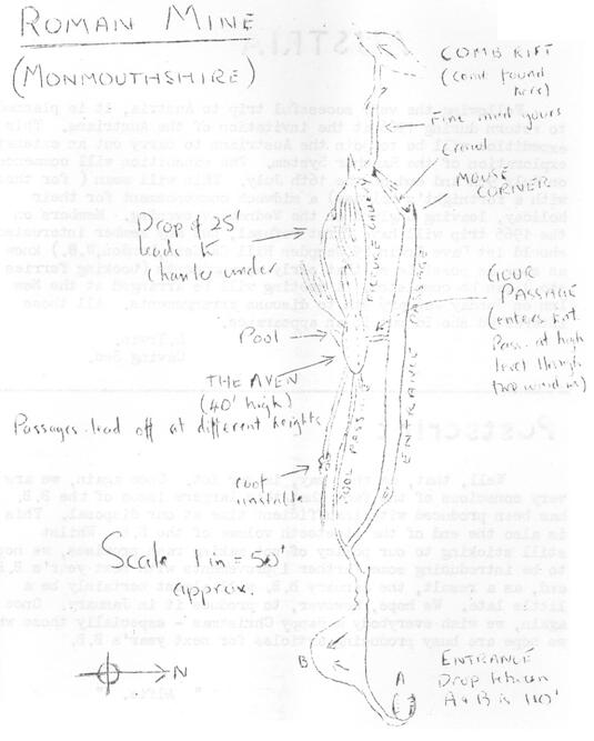
Before we found Roman Mine, it was thought that in this
area, mining during the Roman occupation consisted probably of surface working
and that, if any ore had been taken from thus hill, all traces would have been
swept away by the later mining about 1800. Although Roman coins have been recorded in an unnamed shaft in the
vicinity, there was so little definitely known about this find that it was
possible that they had fallen in from the surface, and all the workings
remaining were assumed to be the 19th Century. We have not been able to find any trace of work of this date in Roman
Mine. No pipes; shoes; footmarks; tools
or shotholes which are frequent in adjacent mines.
The Bone Comb is a rarity as there is nothing exactly like
it recorded and any information from the dark ages especially in
valuable. Its presence in Roman Mine is
a mystery which we, with I.C.I. Fibres Speleological Section, are trying hard
to solve by digging upwards in the rift where it was found. If we can prove that the rift extends to the
surface, it will suggest that the comb fell or was thrown in a passer-by. However, if the rift connects only with an
upper passage, it may be evidence for mining activities between the VIIth and
Xth Centuries, and may be of great importance.
We are working at present on this, also to discover the
original entrance which is still unknown and to find what ore was mined in the
cave as there is some doubt about this. Archaeological investigation is being undertaken by M. Hussey, who has
previously dug a similar site. Because
of this work, we do not wish to publish the actual situation of the mine, but
if anyone would like to visit it and will get in touch with us, we shall be
pleased to arrange a trip.
Editors
Note: Seeing
the subject of this manuscript, we rashly assumed that if it was the work of
Jill alone, and gave no credit to the other half of the Tuck caving Team. We apologise,
next on Mendip. For good measure, the
Tucks address is: –
48, Wiston Path,
Fairwater,
Cwmbran,
Monmouthshire.
Photo Essay
This is our second monthly warning about this competition,
for next years dinner. There are still
ten months to go, but dont get to complacent. It will take a fair amount of work to get between ten and a dozen photos
telling a connected story either in black and white or as colour slides, on
any subject connected with the B.E.C. (Providing it is suitable for showing or
displaying at the dinner next year!) Detailed rules will be coming out shortly in the New Year, but
meanwhile, everybody is getting adequate warning. Here is a real chance for the caving or
climbing photographer to do something more ambitious!
Austria
Following the very successful trip to
planned to return during 1966 at the invitation of the Austrians. This expedition will be to join the Austrians
to carry out an extensive exploration of the Raucher System. The expedition will commence on July 9th and
end on the 16th July. This will mean
(for those with a fortnights holiday) a midweek commencement for their
holiday, leaving
on a Wednesday evening. Members on the
1965 trip will have first refusal, but any member interested should let Dave
Irwin (9
early arrangements (booking ferries etc.) can be completed. A meeting will be arranged at the New Inn on
Sunday January 9th to discuss arrangements. All those interested should put in an appearance.
Postscript
Well, that, as they say, is yer lot. Once again, we are very conscious of the fact
that this larger issue of the B.B. has been produced with insufficient time at
our disposal. This is also the end of
the nineteenth volume of the B.B. Whilst
still sticking to our policy of not making rash promises, we hope to be
introducing some further improvements with next years B.B. and as a result,
the January B.B. will almost certainly be a little late. We hope, however, to produce it in
January. Once again, we wish everybody a
Happy Christmas especially those who we hope are busy producing articles for
next years B.B.
Alfie