
Welsh Cave locations on Google Maps
Registered users can now find cave locations in using a custom install of Google Maps. Over a hundred caves are shown on the map which can be dynamically zoomed and scrolled. To move around simply grab the map with your mouse and move around. When you’ve found the area you’re interested in then use the simple zoom controls to get more detail. Additionally you can choose between a map view, satellite images or a hybrid of the two. Enjoy!Google Maps can be found on the right hand side menu when you are logged in.
An Update from the Blorenge
Toby Maddocks and myself spent the best part of last Thursday 27th October over on the Blorenge. Following on from the fun we’d had the weekend before with the new cave in the millstone I thought it might be an idea to check out the defined series of shakeholes that show up on the aerial photo of the area between our site and the towers. You can see an aerial photo of the Blorenge here. Needless to say that this was unfruitful but at least we can rule them out for now.
One interesting point was that the vertical range between them was about 40m and that the highest is the same height as Cwmwll Ddu. So the limestone may be 40m (or more thick). We are at about 25m at the moment….
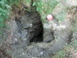
Ogof Cwmwl Ddu Update #3
This weekend saw the biggest team yet assembled for some digging action. The weather was fine and Duncan and I kicked into gear on Saturday morning by starting to haul scaffold poles up the hill. I’d done one carry the night before but lost enthusiasm when it started to rain and my wet weather gear was at home. A two minute job of sorting out the awkward scramble up from the workings into the shakehole changed from simply cutting some steps to installing a stone staircase. At least you don’t fall down the hill anymore.