
Hon. Sec: A.R. Thomas,
EDITOR: D.J. Irwin.
3. Price 1/6d
Contents
Address Changes
M. Palmer,
Roman Way
W. Smart, c/o Richard Costain (CE) Ltd.
Muscat and Oman,
(Bill notes that it takes up to
three months for sea mail to reach him best to use air mail).
R. Roberts, Dept. of Biochemistry & Molecular Biology,
C. Hall, 12 Churly Road,
6.
M. Calvert, 4 Mead Close,
Bridgwater, Som.
Ive just received a bunch of notes from out Hon. Sec. in
addition to those on page 8 which give me a good excuse to publish these
instead of filling the odd space with padding.
Subscriptions
Annual subscriptions are due on January 31st. 1969. Why not give Bob Bagshaw a surprise this year
by sending in your subscription (25/-) and your membership card on time?
Can Belfry users help ensure that the two small sump-heaters
in the toilets are kept filled with paraffin and lit during the winter. The heater will burn continuously for a week
and help prevent the waterworks from freezing. Dont forget to keep the doors closed. It is well worth while to write the date the heaters were filled with
paraffin on the Belfry notice board.
The February Committee Meeting will be discussing two
important topics of interest to all members. The New Belfry and Alfies proposed new constitution. At the January Meeting the Committee
discussed the Exhibition to be held in Wells, CRG Meeting (April) and, as
Norman petty is getting short of timber, the planting of 100 young trees around
the boundary of the Belfry site.
Caving Meets
Sunday 9th February: –
(surveying) Leader: – Dave Irwin.
Sunday 9th March: – August Longwood System Leader: – Andy MacGregor.
EASTER: –
SPRING HOLIDAY: –
Notes on the East Twin Survey
By D.J. Irwin
This new survey was produced to establish the true direction
of the cave. Two surveys, the first
published by the UBSS in their proceedings (1) and the second by the Croydon
Scouts (2), had been inspected by the writer who noted quite considerable
differences. The most important
variation was the True (or Grid?) North arrow. This differed by about 10o indicating although they both claimed CRG
Grade 5, that one of the surveyors had not calibrated his compass. Another difference, though of lesser
importance, was the overall plan lengths. The UBSS showed a length of approximately 127ft. and the Scouts
118ft. The end point of the Third
Chamber from the entrance pothole UBSS = 95ft. and the Scouts 108ft.
The height O.D. levels were at variance. The 1962 Scouts did not quote the O.D. level
but the UBSS and
(3) quote the following values: –
U.B.S.S. (1955) =
600ft.
U.B.S.S. (1964) (4) =500ft.
Apart from the survey differences, the errors in O.D. levels
were too great to be acceptable and so a surface survey line was taken from
Ellick House to the cave entrance.
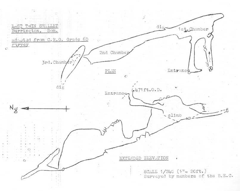
INSTRUMENTS. The instruments used for the cave survey: –
Ex.
W.D. Prismatic Compass
Abney
level (Japanese manufacture)
50ft.
Fibron tape graduated in decimals of a foot.
Both compass and the clinometer were mounted onto a dural
plate and the whole mounted onto a tripod. Two spirit levels were mounted onto the dural plate for levelling
purposes.
developed by Ellis several years ago. The instruments were read to: – compass 0.5o, clinometer 0.5o, and the
distances 0.05ft.
CALIBRATION. The compass was calibrated along a nearby
straight stretch of road and the true North bearing taken from a 6 O.S. survey
of the area.
CALCULATIONS. All values taken in the cave were processed
using four figure tables and a calculating machine. All calculations were checked by re-calculation.
CLOSURES. Traverse closures were not possible as only
one line was surveyed through the cave. All values were checked when being taken in the cave and the finished
drawing compared well with the U.B.S.S. survey (see table at the end of this
article).
PLOTTING. The calculated co-ordinates were plotted onto
graph paper that had been carefully checked for variation in the printed
squares and for paper stretch caused sometimes in paper manufacture. The finished drawing was then traced onto Pertrace
film.
PASSAGE OUTLINE. The passage outline was obtained by the
raying technique and wherever steep angles were involved clinometer readings
were obtained to the nearest 5o. The
values were calculated with a slide-rule and plotted with a protractor onto the
basic surveying line. Roof heights were
measured wherever possible otherwise they were estimated.
SURVEY GRADING. A Cave Research Grading of 6D is claimed for
this survey. The survey also conforms to
the Mendip Survey Colloquium Descriptive Map and the Accurate Outline Survey
requirements.
PERMANENT SURVEY
STATIONS. A small stalagmite flow at
the upper end of the Second Chamber has been marked with cold chisel edge. The co-ordinates are: –
Northing: -51.29 Eastings: – +23.13 O.D. 427.58
(NB. Both N and E are
taken from the datum lines originating in the Third chamber.)
LOST PASSAGES. It is apparent that since the U.B.S.S. survey
that considerable changes have taken place in the cave. The first aven, shown on the U.B.S.S. survey,
could not be located even though a considerable time was spent searching for
it. The entrance to this aven is shown
to be very near the floor level and, probably due to later floods, the stream
has deposited considerable quantities of infilling blocking the entrance. The Scouts survey does not show this aven;
neither do they show the connection between the stream passage and the entrance
passage as can be seen on the U.B.S.S. survey. This connection between the two passages seems to be blocked with fairly
large boulders.
COMPARISON WITH
EARLIER SURVEYS. As figures for the
two earlier surveys are not available the only check that could be made as to
the accuracy was by measurement of the main points within the cave from all
three surveys.
|
Direct |
Total |
|
U.B.S.S. 95ft. Scouts 108ft. B.E.C. 94ft. |
|
|
|
|
|
Direct |
|
|
U.B.S.S. 127ft. Scouts 118ft. B.E.C. 129ft |
|
|
|
|
|
Depth |
|
|
U.B.S.S. 55ft. Scouts 71ft. B.E.C. 56ft |
|
Copies of this survey (original drawn 1/120 scale) are
obtainable through the cave survey scheme. The price will be approximately 3/6.
Acknowledgements.
The assistance given by R. Bennett, R. Saunders and G.Tilly
is gratefully acknowledged. Without this
help the making of the survey would have not been possible.
References.
(1) U.B.S.S.
Proceedings 1957/58.
(2) Unpublished
survey by Croydon Scouts (1962).
(3) Caves of
Mendip,
(4) U.B.S.S.
Proceedings 1964/65.
(5) Additional
references not mentioned in the above text: –
CRG Trans. 8 (2) Cave Surveying,
Butcher and Railton (1966).
Survey Colloquium Report (1963).
B.E.C. Caving report, S.J.
Collins Presentation of Cave Survey Data. 1966.
Notes of the surface
line from Ellick House to the Entrance of East twin Swallet.
The levelling exercise was carried out by Bill Smart, Keith
Franklin, Dudley Herbet, Tim (Hodgoon) Hodgson. Bill used a Quick-set and took the line along the road leaving a
number of side legs along the way near other cave entrances so that their
respective O.D. levels can be obtained in the near future. The line was carried on down the Coombe and
ended at the entrance to Avelines Hole. Although the line was not closed, errors would not be greater than
±0.5ft.
D.J.I.
This is the first of a series of the new B.E.C. surveys;
next month will be Roger Stenners Avelines Hole to C.R.G. Grade 6. During the year up to date surveys will be
published of Sidcot Swallet (the first accurate survey ever!)
(with comparison with the 1968 survey by Dick Warburton) and Roman Mine (found
by Jill and Norman Tuck) together with a full report of the important finds
made there. The surveys published in the
B.B. will only be an outline and a selection of passage sections. All of the complete surveys will be
obtainable through the Mendip Survey Scheme full details of this later. More parts of the Cuthberts survey will be
on sale next month get your orders in now to Bryan Ellis and take advantage
of the reduced rates the last for the first month sale only.
South Wales Meet – Aug 68
By Dave Glover
Andy MacGregor, Jane and myself arrived at the Gwyn Arms
soon after mid-day on Saturday 31st August. Tents were pitched opposite the Gwyn and then a few minutes were wiled
away in the traditional manner. At
closing time there was no sign of the expected B.E.C. arrivals so it was
decided to take to the hills. A climb up
the track behind the Gwyn and a little searching enabled us to find Pwll Dffn
Pot. From there we had a look at several
interesting shake holes and one very large sink, taking only a trickle on this
occasion. By the time we had returned
Phil Kingston, Colin Priddle, Mike Palmer and Dave Yendle had arrived. After the evening brew-up we all retired
once again to the Gwyn (theres a Courage a mile down the road! Ed.) where we
were treated (??) to the skirl of bagpipes! Bagpipes in
I ask you! Completely shattered (from
the bagpipes, not the beer!) we staggered back to the tents accompanied by a
gentle drizzle.
The morning proved that it had not remained so all
night. The river Tawe was running at
least four times its volume more than the previous day, and leaden skies were
still debauching large quantities of water. Our intended trip into Dan-yr-Ogof was beginning to look decidedly
dodgy. Perhaps I should explain to
anyone who is not familiar with D.Y.O., that soon after the show cave ends the
stream is met in the form of two lakes. In wet weather these sump and this being the only way through, the
prospects of doing the cave in wet weather is not very encouraging. At 10 oclock (still pouring) despite the
notice Cave open to visitors, D.Y.O. showed no signs of life and with no
prospect of finding out the conditions of the cave, it was decided to abandon
the trip. We all drove to
taken and then to the South Wales Cottage. By now the weather was clearing slightly and it was decided to do O.F.D.
2 to the waterfall via Cwm Dwr. At
midday the party finally started its descent though a peculiar concrete
tube. We soon overran the turning to the
first crawl. It was noticeable that
those who had done this trip before allowed the others the first opportunity of
sample the delights of the crawls. The
total length of the three crawls is about 400ft. The first takes a trickle of water and is
mainly smooth rock; the second is pleasantly sandy and flat out in the middle section;
the third is gravely and a bit hard on the knees. Nevertheless, they made a sporting start to
the system. After this the character of
the passages change quite dramatically to large passages 70-80ft. high in
places. We soon came to one of the few
formations in the cave; a white stal. flow. Some very interesting sand and mud formations can also be seen in
various parts of the cave, but although most are taped off they seem to be
suffering from the attention of the heavy boot brigade and some have been
completely destroyed over the last 18 months. Soon after following the Cwm Dwr stream passage we came to a dodgy
looking boulder ruckle that connects C.D. with O.F.D. This must be more stable than it looks
(famous last words) for it gets a considerable amount of traffic through it and
shows no sign of movement. Once through
we were in O.F.D. and there followed a delightful piece of caving, mostly
gentle walking over soft sand in airy passages. After taking all the correct turns we arrived at the streamway. This had taken about 1½ hours and after a
short rest we set off up the 1½ -2 miles of streamway. At first this was greeted with enthusiasm,
with mush splashing and shouting. The
streamway is a most interesting passage with small waterfalls, deep potholes
which have to be swum and interesting rock formations some of which were
razor sharp. The one big problem is
thats almost impossible to tell whether your next step is going to land you in
six inches of water or six feet, so that after ½ an hour it was noticeable that
great concentration was the order of the day. After an hour of this the climax of the trip was reached a superb
25ft. waterfall. After a few minutes
rest and time to admire the fall we turned back. The journey back was uneventful except for a
couple of wrong turnings. The total time
of the trip was about 5 hours.
*****************************************
All Library Books To
Be Returned To Dave Searle By Mid-February
The Route Severity Diagram
A new system of describing caves
had been developed by Alfie, first explained in the BEC Caving Report No.12
and since that time modified by the addition of certain symbols, is now part of
a new B.B. series
.
By S.J. Collins
PART 1. Introduction
For most purposes, the ordinary type of cave survey is quite
good enough and the fact that surveys have been used by cavers for many years
bears this out. The trouble starts when
caves are very complex like St. Cuthberts come along. The normal type of survey of such a cave
system contains many passages and chambers which lie over each other on the
survey, and this begins to make reading such a survey a difficult process.
To any caver who is using a survey for measurement purposes
as an aid to further exploration perhaps, or to plot the course of streams,
or to trace the underground bedding of rocks, there is no substitute for an
accurate survey of the normal type, however complicated the cave. A caver doing the sort of work already
mentioned will not mind the time he may have to put in when sorting out what
goes where from the survey. On the
other hand, the normal caver, who merely wants to know how to get from A to B
and what difficulties he may expect to encounter on the way needs a simpler
method of seeing where he is.
The problem bothered me for a number of years, and I thought
it might be possible to invent a simple diagram rather on the lines of a
circuit diagram used in electronics. The result is the Route Severity Diagram. Since I first started to interested other
cavers in this method of writing down the features of a cave, I have been helped
by many useful suggestions, and the R.S.B. in its present form is the result of
the help which I have received from many cavers, all of whom I should like tom
thank.
The R.S.D. has now been adopted by the Mendip Survey
Colloquium as one of the preferred ways of drawing a Descriptive Map of a
Cave. To well known surveyors are at
present engaged in producing R.S.D.s of caves, which will soon be
published. I thought that readers of the
B.B. might like a short (and painless!) course on reading this type of map, so
that the surveys will not seem so strange when they start to appear. A very short article will thus appear in
each issue of the B.B. for the next few months. Each part will teach a part of the system and should not take too much
wading through.
PART 2. Passage and Pitch
The Route Severity Diagram ignores the actual shape of the
cave, and simplifies this into two forms the passage, and the pitch. These are drawn below.
Pitches are drawn with the one side open to the adjacent
passage and one side closed as shown below. The UPPER passage is the one which is closed. It is easy to remember which is which if you
think you can walk straight into the centre of a circular pot from the bottom,
but not from the top unless you can fly!
Thus, only knowing these two simple designs, you can see
from the R.S.D. whether the cave is mainly vertical or horizontal, and where
the pitches are.
All the passages on an R.S.D. are drawn parallel to or at
right angles to each other. To get them
to fit, right angled bends are often made in the passage. These are ignored but what remains true is
that every passage junction is correct. Thus, in an R.S.D. of Swildons, for example, a junction would be shown
downstream from the Wet Way showing straight ahead for the 40 (or was that
the 40 before the flood!) and turn right for the Old Grotto and the Dry ways.

Thus: – 1. Passages are shown by parallel lines. All passages are the same width. All junctions and bends are right
angled. Bends should be ignored,
junctions are correct. 2. Pitches are
show by circles. The upper passage is
shown blocked and the lower on open to the pitch.
The next part will deal with CONSTRICTION.
Penyghent Pot
By Martin Webster
During December, Dave Turner (BEC), Brian Woodward, Brian
Talbert, Bob Craig (SMCC) and myself, spent a weekend in
with the aim of bottoming Penyghent Pot. Although this cave is no longer the deepest in
still ranks as being very severe if tackling and de-tackling is to be competed
in the same trip.
Our first problem occurred on the M6 when the throttle cable
on the dormobile, in which we were travelling, broke. Two hours and a tow from a rather disgruntled
R.A.C. man, later we were on the move again; cable being joined with string!
After various stops we eventually reached Skirwith Farm at 5
oclock in the morning and in sub-zero temperatures we quickly erected tents
and tried to get a few hours sleep.
The next day, after sorting the tackle and having breakfast
(which was in fact lunch by the time we arrived at the café) we set out for
Penyghent. The game-keeper was informed
of our intentions and then we drove slowly up the track onto the fell.
The weather by this time was quite good and there seemed
little likelihood of rain, so with high hopes we rapidly changed and started
off across the moor top the cave. At the
cave entrance Dave sadly decided that he could only help us as far as the end
of the canal, as the wet suit he had made out of very thick industrial neoprene
was acting like a straight-jacket. We
all agreed that, in the circumstances, Dave was probably right and so we
resigned ourselves to the thought of having to carry all the tackle with only
four people.
It took 25 minutes to get along the canals to the first
pitch. The passage after this, which
leads to the second pitch, is called the Second Stretch and was most probably
the most backbreaking place in the cave. The top of the main pitches was soon reached and the 60ft. vertical was
found to be climbable, although a ladder was hung for the return trip. For the 70ft. pitch, the ladder was hung
under a low roof of rock on the right; in this position the pitch was quite
dry. At the bottom we entered the Main
Chamber though not as large as I had expected, was still and exhilarating
place.
The way continues as quite a tight rift, broken at regular
intervals by short pitches, some of which were possible to climb without
tackle. At one stage belays had been
forgotten and so a return trip, through an extremely nasty, wet crawl had to be
made to fetch them.
We made rapid progress, and after a chest deep walk through
freezing water we emerged in Boulder Chamber, the only fairly dry place in the
cave! The following pitches seemed to
get wetter and wetter and the waterfall at
(the final pitch in the cave) was a fantastic sight.
The lower main stream did not really seem to take on the
proportions we had been expecting, although the water does get quite deep in
places. When we finally reached the sump
it appeared so suddenly that Bob jumped in to make sure we had really got
there!
The return to Boulder Chamber was quite fast and here we
munched our way through a pile of chocolate and mint cake. The short pitches were soon passed and the
main pitches were found to be not quite as bad as we had feared. By this time we were carrying nearly as much
water in out tackle as tackle, and so Second Stretch was found to be
particularly arduous. A welcome change
of technique came when the canals were reached, however, by the time we eventually
reached the tight entrance shaft, after 6½ hours underground, a distinct
dislike for canals had been developed!!
Feeling suitable pleased with our efforts we raced down the
hill and reached the dormobile in record time. Following a quick change we were soon enjoying pie and peas in one of
the local pubs.
In retrospect, the cave was just as severe as we had thought
it was going to be. If a team with
previous knowledge of the cave did it, very much less tackle would be needed,
as we found the shorter ladder lengths and belays (than listed in P.U.) were
sufficient and some of the pitches could be climbed, although great care in the
far reaches should be exercised. The
cave appeared to be extremely liable to flooding; great quantities of foam were
seen in the lower passages! To a strong team however, in dry weather the
bottoming of this pot would be very pleasant and technically rewarding trip.
Just a Sec
With Alan Thomas
Thank you to all hose who have contributed either their
own cash or their ingenuity in wresting cash from others for the Hut Fund. Most recently Robin Richards got £2 in the
Hunters by passing the hat round after a short burst of drunken carol
singing. Any bright ideas for 1969? Thanks also to Joyce and Pete Franklin for
catering so admirably for the Belfry Christmas and to Robin (of the carol
singing fame!) for donating a barrel of beer for the same cause.
I dont know if any of the B.E.C. met Hans Siegls son,
Wolfgang, at the 1966 Raucherkar Expedition, but we learn with regret of his
death in the Dachstein in October. Older
members will also be saddened to hear of the death of Les Browne. Members will remember Mr. Brownes activities
at Brownes Hole.
Dave Smith has taken over the Postal Department of the B.B.
and we should be grateful to him for volunteering for this arduous task.
Monthly Notes No.20
by Wig
WATER TRACING
again! Throughout the week January 6th
11th the new King of the Mendip Karst Police (Tim Atkinson) and his consort
Malcolm Newson organised another session of filling the swallets of Mendip with
lycopodium spores. This month the swallets of interest were those in the
Hillgrove area. Each
of the swallets (Hillgrove, Easter, Rock, Zoo & Whitsun) received 2kg. of
spores that had to be pumped into the holes with the aid of water in Hillgrove
pond and hoses from the Yeovil Fire Service. The risings being checked are
Wookey, Glencot, St. Andrews, and
Wells), Biddlecombe, Chilcott and Dinder. It will be a few days yet before even the provisional results are
known. The interest in these sites,
normally dry, lies in the recent work by Tim Atkinson, when he placed a salt
solution in one of the swallets in the Hillgrove area and traced the solution to
Biddlecombe. The time taken was only 4
hours and if you look on a geological map you will notice that theres a very
nice block of sandstone in the way! I
understand that the next area to be checked is in the Waldergrave pool
district.
PUBLICATIONS Will all Club Secs note that EXCHANGE COPIES
of their publications should be sent to our librarian DAVE SEARLE, DOLPHIN
COTTAGE, WELLS ROAD, PRIDDY, Nr. WELLS, SOM.
THE FLOODS AGAIN
As a result of the July 1968 floods another small cave
system has been revealed and lost to Mendip cavers. The cave is situated in the field immediately
opposite Tynings Farm (grid Ref. 4715.5637) and was found by members of the
A.C.G. in October last. First entered by
Tony Jarrett (A.C.G.) and James Cobbett (W.C.G.) the cave has a length
(estimated) 250 300ft. and a depth of 90 100ft. An entrance shaft of some 10ft. in clay led
to a chamber and a deep rift. From the
rift a major passage leads steeply downward and is remarkable for its
cleanliness. The general passage shape
is square and is more or less a walk passage for most of its length. Another chamber is soon reached, with a few
stal. formations, where a small inlet stream enters. This stream can be followed to a terminal
choke where it sinks in a choked rift.
The farmer, learning that a cave existed in this particular
field was far from pleased. He planned
to use this field for cereals and that cavers would in all fairness be a hazard
and a nuisance. The cave was to be
blocked but before this took place the explorers had a couple hours grace to
photograph and produce a rough survey. The survey has been published in the ACG Newsletter and the Mendip Caver
(both in the BEC library) while the photographs are non-existent due to a
faulty flash gun. The position of the
entrance was later measured and presumably the figures can be obtained from the
ACG. The general direction of the cave
is towards G.B.
SWILDONS North West
Stream Passage
The latest issue of the Speleo (SWETC Caving Club) includes
notes and surveys of their discovery. The N.W. Stream Passage has been photo reduced to the same scale as
Willie Stantons published Swildons so that it can be easily attached to the
basic survey. Talking of surveys, the
survey of Plantation Junction to the Sump of St. Cuthberts is now at the
printers and should be available soon.
LONGWOOD/AUGUST
SYSTEM
Charterhouse Ive been assured by Tony Knibbs, Sec. of the
C.C.C. that the new gates will be finally fixed to the blockhouse and at the
top of the entrance shaft by mid-January. New sets of keys will be sent round to all member clubs as soon as
possible.
THROUGH TRIP IN G.B.!
As many will already know a considerable amount of slumping
was responsible for the huge quantities of mud in the Gorge and recently this
slump pit settled again near the surface opening up a route through boulders
leading to the top of the Gorge. Its
unstable state caused it to collapse again thus blocking the new entrance
again. One can almost hear the sigh of
relief from the U.B.S.S.
SYMPOSIUM ON CAVE
PHOTOGRAPHY
8th March 1969
of
to
Kodak); Expedition photography (A. Wicks, Pegasus); Flash photography (Unwin,
Philips El. Ind.); Equipment review (Coase, B.E.C. & S.W.C.C.); Close-ups
in caves (Dr. Wooley, I.C.I.); Stereoscan techniques (Dr. Ford, P.D.M.M.S.);
Aerial photography & Investigation of Karts Areas (Dr. Norman, I.C.
London); Early experiments with cine (E.K. Tratman, UBSS); Expedition equipment
review (H. Lord, B.S.A.); Final discussion. Evening films; Lamb Leer 1938, the Journey, etc. Apply to Alan Thomas for further details and
application forms.
Larger B.B.s
Instead of one large issue each year at Christmas two will
be appearing during the course of this year Spring issue march 1969 and Summer
issue August 1969 and of course Christmas issue Dec. 1969.
The increase in the number of pages will give all those
members a chance of putting pen to paper who normally feel that there is not
sufficient room in the B.B. for their material!
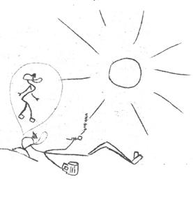
The role of hut-warden is at best an unwelcome task Phil Townsend (November B.B.)
CAVERS BOOKSHELF
DESCENT, No.1. January 1969. Published every six weeks. Price
2/6 each. Edited by Bruce L. Bedford.
What! You may say, not another national caving
magazine. Havent we had enough trouble
with the other! Its quite true, another
national magazine. 28 pages and the same
size as the old B.B. format (Sixmo) it proves to have a drive about it that
will no doubt prove quite a competitor to the established other (which is
awakening from the dead once more!). The contents include an interesting account of a newly discovered
Norwegian pothole descended to -698ft. and still going. The Border Caving group and their low cost
laboratory is fully described and well illustrated with photographs. The Ptezl descender and the
two interesting articles, a section of snippets and a final article by John
Wilmut entitled Three-prong policy for Pengelly Centre. A very good half-dollars worth. D.J.I.
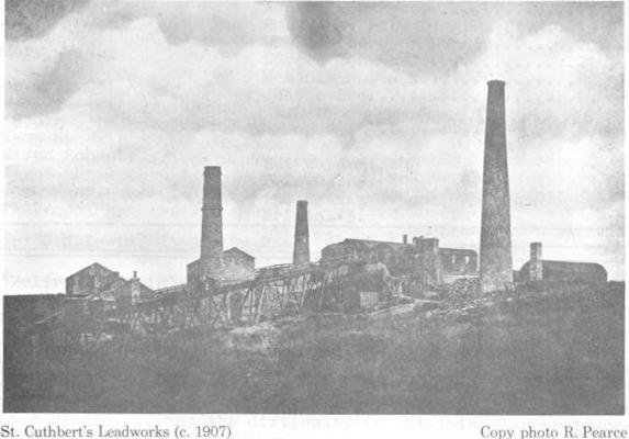
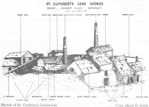
CUTHBERTS LEADWORKS
Most members, at some time or other, will have walked or
staggered over the ruins of the St. Cuthberts Leadworks. On the facing page we are reprinting from the
report on St. Cuthberts Swallet a pair of photographs of the leadworks taken
just before closure in 1908 (top) and the photograph of the sketch was taken
from a print owned by Mr. Burton, Priddy, who said that it was sketched by a
local schoolmaster about 1905. The
photograph appeared in the Yeovil area and was copied by Roy Pearce (M.N.R.S.)
and has been published in the Cuthberts report and British Caver. Mr. Burton also owns the foremans ledger for
the period 1907-1908 and it is hoped that extracts will be available for the
B.B. later this year. Even just before
closure quite an amount of building was going on at the site the third
chimney in the top photograph being added sometime in early 1907. In July 1907, an entry for photographs
costing 15/- was made and presumably the copy opposite was one of these. The photograph circulated by Gilbert Weekes
several years ago to B.E.C. members seems to be quite common in the Priddy
area. When it was taken is unknown but
it is certainly before 1907.
Members looking for this type of material should look
through any old postcard collection they may find. At the turn of the century it was the thing
to send your friends post-cards, even though it was just an afternoon
outing! Commercial photographers snapped
just about everything there was to take however ugly. Just one final point several post-cards
were prepared for the Cheddar cave both Coxs and Goughs which are worth
looking for.
MENDIP CAVE REGISTRY IN
TROUBLE
Your Editor has just received a letter from Kay Mansfield
regarding the latest situation of one of the important backroom groups of
Mendip Cavers. Kay thanks the B.E.C. for
their financial help and support in sending our publications to the Bristol
Central Reference Library and she reviews the major items of work carried out
by the registry up to now. These
briefly are a) the Mendip Cave Register, housed in three public libraries
(including Bristol) lists all known caves and sites of caving interest together
with a full bibliography of caving journals which become b) the Mendip Cave
Bibliography published by the C.R.G. and finally c) the Registry persuaded the
Bristol Central library to start a cave publication section (which I may well
add is one of the more used sections of the entire Central Reference
Library). A catalogue of the collection
was published in March 1968 by the Registry.
At one time the registry was in financial difficulties and
the Governing Body (principal Mendip clubs) gave all the money asked for. Now, says Kay, there are financially sound
and may never need to ask for money.
Kay continues
However things are not as they should be in
that the Executive Committee of the Mendip Cave Registry is well below the
number required to run it and things are not improving. Over the past year the Committee has dwindled
to a very small number of enthusiasts, needless to say the people remaining are
the usual steadfasts. What in fact is
needed now an injection of fresh blood into the registry because a considerable
amount of work still needs to be done and there are just not enough people to
do it.
To sum up. It is
certain that without new members elected to the Executive Committee, the Mendip
Cave Registry will virtually cease to exist and I firmly believe that the
member clubs of the Governing Body would not be happy about this. The Registry has certainly proved its worth n
times over; it would be a pity to drop it now. Anyway perhaps I could leave this matter with you
..and if your club has
any spare bodies who think they could help the Registry they are cordially
invited to meet at Phil Romfords caravan, behind the petrol station at
Townsend, Priddy on Saturday 8th March 1969 at 6.30pm.
STOP PRESS
Water Tracing Results: Hillgrove, Easter, Zoo, Rock and Whitsun all resurge at Wookey; also
all (except Easter Hole) resurge at various risings in Biddlecombe.