
Contents
Mossdale
In spite of the fact that an impression is gained by members
of the public through the publicity which follows each caving accident that
caving is a dangerous sport, the fact is that it remains remarkably safe
considering the very large number of people so regularly involved.
In this setting, the tragedy of Mossdale becomes one of a
scale which we hope will never happen again. There is little we can add to what already appeared, except on behalf of
the club, to extend our sincere sympathy to all the friends and relatives of
those who have died do suddenly and tragically.
Alfie
Long Term Planning.
Little has been mentioned of late, but the report has now
been prepared and, after typing and duplicating, each member of the B.E.C. will
be receiving a copy. This is a subject
with far reaching consequences, and every member is urged to give the report
his full attention.
Nine Barrows Swallet
It is not often that we are able
to print an article on a new Mendip cave. Not a major cave as yet but there is still time for that to happen!
Nine Barrows Swallet is to be found in a field at the top of
Eastwater lane on the right hand side. Although it is not a very large swallet, it takes a fair size steam in
times of heavy rain. Geologically, it is
on the shales, O.R.S. and limestone boundary and almost on the junction of the
East and West Priddy Faults, so it is easy to understand why this swallet has
attracted the attention of various people over the last eight years.
The first person to dig there was Mike Holland of
B.E.C. and
and they dug together for a couple of years, getting into a small chamber in
boulders with no obvious way on.
with the help of Mo Marriott and the
brothers, all of the B.E.C. They
followed the stream down and excavated a hole some five feet by four feet in
section and five feet deep. At this
point, Jim Giles lost interest due to the apparent instability of the dig and
because of other commitments on
digging continued spasmodically until Marriot joined the Brain Drain some three
years ago. The stream now entered into
what looked like open cave, but this was unfortunately only six inches
wide! This setback also coincided with
the onset of winter which made digging extremely unpleasant as the stream found
interesting diversions like down the neck and out of the trouser leg (it was
just pre-wet suite era). So support for
finding an alternative route was sadly lacking and, except for a few isolated
occasions, work ceased until May 1967.
Renewed activity at the swallet was prompted by a
coincidence. The
Fairmans Folly collapsed after heavy rain. This upset their digging programme, and so they were looking for another
dig in order to keep their team together. Nine Barrows also suffered a collapse (Old Moore Giles was four years
early in his prognostications!) but what in normal circumstances would have
been a calamity, turned out to be a blessing, for it revealed an easily
accessible choked rift. The
for permission to dig and, on being granted this, put in an extensive effort
for several weekends. The new dig was
about five feet above the old site, as the top of the shoring Marriot and
Franklin had put in could just be seen at floor level.
Progress, mainly by A. Sural, S. Church and J. Cornwell, was
fairly rapid until just before Whitsun when the way became blocked with
boulders, although empty space could be seen beyond. Those boulders were successfully removed by
J. Cornwell, aided by several B.E.C. members on Friday 13th June, showing the
cave to be open. It was decided to wait
until Saturday before descending in order to give the other
concerned an opportunity to be on the first trip.
Duly, the B.E.C. contingent (A. Thomas, P. Coles, J. Manchip
and the
brothers) assembled at the appointed hour at the cave and waited. After an hour had gone by, it appeared that
the rest of the combined party were not going to be able to turn up, so a
reconnaissance trip was decided upon. (This was not necessary in fact, as it turned out later that a
has already been down earlier that morning). The tight entrance opened out into
a fairly large chamber some thirty by twenty feet and fifteen feet high. This had a few side passages with interesting
but not spectacular formations and a sloping boulder floor leading down into a
water worn rift seen feet high by two feet wide. The roof of the rift consisted of jammed
boulders but most of the wall was solid rock. The stream or what was of it was met about twenty feet down the rift
and, apart from one detour, could easily be followed. It was at this detour that the party decided
to go back and find the rest of the party before continuing. However, the
Cornwell, J. Church, T. Dingle and H. Brown were met after retracing only a few
steps. J. Cornwell then took the lead
and progress continued downwards with the rift getting smaller and smaller and
finally ending in a flat out crawl. Just
before this the stream disappeared into an impenetrable rift on the left.
Various probings in the rift revealed nothing of any
importance, except that it was all very unsafe. The end of the crawl led to what looked like the beginning of a boulder
choke with the probability of a way on in the floor. Plans were made to come back the next day and
explore these and other possibilities which presented themselves on the way
out. On returning to the surface, it was
decided that a temporary gate should be erected at the cave entrance and work
was started straight away (This is now a permanent gate, with keys held by the
B.E.C. and
who jointly control access). Also, that
same evening, the end of the crawl was banged and, with high hopes for the next
day, the party adjourned to the Hunters.
Sunday the 15th June produced the major discovery of the
weekend. The bang was successful and,
instead of a boulder choke, a large chamber was entered. It was some seventy feet long by thirty feet
high and had fine crystal walls and formations, but again, disappointment
followed. This chamber was a dead end
and, although the stream could be heard below, but no way could be found to get
at it. The pot at the end of the crawl
was still too tight to get into, so further chemical persuasion was used. The bottom proved to be choked and other
alternatives are now being examined. The
present position is that Nine Barrow has gone and with any luck is still
going right down to Wookey.
K. Franklin.
Monthly Notes – No 5
by Dave Irwin.
August Longwood System. Members wanting a trip into this system will
be able to obtain the key from Gordon Tilly at the Belfry. To ensure that the key is available when you
want it, drop Gordon a line at his home address, Jable,
until the new tenant moves into the farmhouse. Mr. Young retired recently.
Corrections. In Monthly Notes No.4, read WHITE SCAR for
WHITE SPOT. Also, Flint Ridge and
200 miles!
Charterhouse Caving Committee. In the absence of Prof. Tratman, who has
joined the U.B.S.S. expedition to
appointed acting secretary.
Electrolyte. Is available at the Belfry. 2/6 for a complete refill. Carbide. This is available at the Belfry at 1/6 per lb.
St. Cuthberts. The Main Traverse covering the main framework
of the cave has now been closed and corrected. The closure error was 0.54%. Production of the various parts of the report are now going ahead to
schedule with four parts being published later this year. These will be History of Exploration, Gour
Hall, Rabbit Warren and Old and New Routes. Surveys are to C.R.G. Grade 6. SEND YOUR ORDER TO BRYAN ELLIS FOR THE WHOLE
FIFTEEN PARTS AS SOON AS POSSIBLE to enable him to determine numbers to be
printed. Part O Miscellaneous Information,
including a complete bibliography up to August 1966 is still available price
2/6.
New Books. History of Mendip Caving by
P. Johnson, published by Davis & Charles,
Abbot,
mineworkers to the present day. The text
is well written and holds interest. The
author a member of the U.B.S.S. is biased towards the discoveries of that
club and has a rather low opinion of Balch and his associates. Photographs include most of the other major
caves on Mendip but none Cuthberts. In
general, the photographs are of a very low standard, considering that most are
not of historic interest. Mines of
Mendip by J.W. Gough. This classic work
is being revised and reprinted in the autumn. Price about 35/-. Same
publishers.
Malhan Cove,
been discovered near the resurgence.
Nine Barrows Swallet. Has at last gone. (See article Ed). The boulders at the entrance are unstable, so
take care. The East Somerset C.C. are
now digging under the decorated chamber at the end of the system. 1/- entrance fee is to be paid to Gordon
Tilly on behalf of the landowner. The
key is kept at the Belfry.
Pant Mawr, South
series of new passages.
Poem
The Editor, of late years, has managed to restrain his
natural tendency to indulge in horrible rhymes, but now and then, things get
too much for him. Overhearing a
conversation in which most of those present confessed to not knowing the
meaning of the word prognostication in the article on Nine Barrows Swallet,
he has not been able to resist the following comment
Prognosis
What a sorry situation
Now the word prognostication
Has become a mystery
To members of the B.E.C.
I say again, as adumbration,
It is a sorry situation
When pentasyllables are banned
Because no one can understand.
Oh, higgorance! Oh, sorry state
I venture to prognosticate
That this ere modern heddication
Will lead us to a situation
Where, even with a predilection
For the shorter word prediction,
Authors to avoid a mess
Will have to call the thing a guess
Four letter words will fill each page
Of B.B.s in some future age.
Editors
Note. Sorry about the above, but you
will have a new Editor soon who may well be freer from such outbursts!
Ireland
June 1967
by R. Bennett and D.
Irwin
First Week Activities Various.
After a not to be recommended crossing, the Bennetts and
Dave Irwin arrived at
to investigate the attractions of the Emerald Isle.
Mitchelstown New Cave, Co.
paths only, and lit by a Tilley lamp carried by the guide plus a few candles
carried by the party. The trip was well
worth while, however, as the formations are very good and must be photographed.
Base camp was then set up in Co. Clare, and in spite of the
weather (hot and sunny) the delights of Polnagollum and Poll an Ionian were
sampled. The latter cave was difficult
to find without a large scale map. It is
situated about a quarter of a mile South West of Ballynalacklen Castle at the
bottom of the largest of the cliffs in the valley. Its main feature of interest is a large
chamber containing an enormous fluted hanging stalactite which has been
measured and is twenty five feet long.
for any caving party, if only to do the impressive meandering Main Stream
Passage.
To avoid further difficulties with the weather, a trip was
made to look at the Burren. This is a
unique area of upland limestone similar to some of the classic Karts areas of
have been denuded of the most of their soil and show great areas of bare
limestone pavements and cliffs. The
valleys contain many hollows and depressions, the largest and most spectacular
which is the Polje of Carran. This is
a more or less flat bottomed valley, completely enclosed, and about a mile wide
and several times this length.
has very many low lying sinks which have never been penetrated. The Fergus river sink is one such and was
visited to look at its caving possibilities. It is a large sink in a small steep sided valley and clearly often takes
a considerable amount of water, which sinks in numerous holes. Several possible sites for a dig were noted,
and some probing was done in a choked rift in the valley bottom past a few
yards downstream from the right hand aside of the sink proper. This looked very promising and easy to
excavate.
As water conditions were still very low, a look was taken at
the
many enterable holes, and in spite of local opinion the there was no cave
there, wet suits were donned and the holes thoroughly pushed. They all led to a network of open joints and
bedding planes occupying the space between the outcrop surface and standing
water at river level a height of ten feet. Everything closed down apart from one sump, which was rather similar to
the other passages and probably closed down also. This brilliantly confirmed the locals opinion
of the absence of a cave, but the lack of development was rather
unexpected. The sink, which takes water
from the shales, is only about half a mile away, so there should be no lack of
aggressive water at the rising. This
could be spread out just below the valley surface in a network of joints
already opened by surface erosion, but even these would be expected to
concentrate into more continuous passages near the rising. Local opinion has that the sink and rising
are not connected as the sink water is peaty and that at the rising is always
clear. There is a profusion of water
weed at the rising suggesting that this is a spring percolation water of high
carbon dioxide content. If this is the
case, the sink water must resurge elsewhere, and the absence of cave
development is explained. There was,
however, no time to study this matter further, as the party intended to move to
the
site in Co. Mayo.
Second Week
Aille
River
Cave
Actually a visit was paid to this site during the first week
on 15th June, and what appeared to be a new cave, was discovered.
The Site.
The
lies some six miles East South East of the town of
hundred foot long by forty to fifty feet high limestone cliff. At the point of engulfment the water flows
under a wide and rather shattered bedding plane cave which ends in sump. This was the previously known extent of the
miles away to the East at Bellaburke, discharging both from small fissures and
directly into a large pool, thence flowing away as a large river in a southerly
direction into Lough Mask.
J.C. Colemans excellent book The Caves of Ireland refers
to two accounts of early entries into the cave, but details for when these
entries occurred or how far they reached have been lost. The local inhabitants are quite convinced
that the whole area will collapse into a vast hole. At frequent intervals, depressions appear but
most of these are filled in immediately with stones, clay etc. One recently was opened up by a plough and to
quote Mr. McGreevy, a local farm manager, the hole about the size of this
room (about ten feet square). Along the
track, a short distance from his cottage, one can walk on what is hollow
ground. By stamping the ground, a
definite booming sound is heard. It is
proposed to tarmac the surface of this track. Heaven help the roller driver!
The river rises some eight miles away on the Western slopes
of the
twenty square miles of countryside. During the winter months, and often in May, the cave is subject to
severe flooding when water reaches a depth of some forty feet at the sink and
several square miles of peat and bogland are inundated. When the water rises to a certain level, it
overflows into a valley to the North of the sink and pours into a large
elongated shake hole with a flat boulder floor at one end. This fills up after two hours but usually
empties again rapidly. The shake hole is
mainly in alluvium and probably is on the old surface course for the
river. Although the floods are severe,
they rarely last more than twenty four hours, but it can take little more than
an hour for the flood water to reach the sink in bad conditions.
Exploration.
In the field a few yards behind and to the right of the
cliff there is a large shake hole. A recent
collapse in the side of this has left an open hole of considerable dimension
down which the sound of running water could be herd. A quick inspection showed that an unimpeded
descent could be made to a river chamber leading to deeper water. This seemed just too good to be true, and
before changing to explore further, we had a chat with the local, the
aforementioned Mr. Patrick McGreevy. He
confirmed that earlier in the year some C.P.C. members had been there, but had
been hampered by flood conditions so that they were apparently unable to get
very far.
The entrance shaft was some eighteen feet dep. At the bottom of this, a scramble over a
boulder led us to the river in a wide chamber with several rock pillars which
created some confusion as to its real shape. The river entered from our left from a boulder ruckle. This was followed for a few feet only,
although a way on could be seen. Moving
downstream through a lake, a canal was entered on the right and followed for
nearly two hundred feet. We traversed
along the side of the right hand wall clambering over submerged boulders. The water to our left was much deeper, and at
times out of our depth. After a hundred
feet or so, a mud slope was reached. This slope led to a high level chamber which was well decorated on the
upstream side. A passage continued above
the formations, but was not followed for fear of damaging the stal. flows. A boulder fall was soon met and at least two
places showed that the passage continued on the other side. Time idi not allow us to garden this
passages, so they were left. Returning
to the short canal, we followed it for some distance only to find that it
sumped. At this point, the water
deepened considerably. On returning to
the entrance chamber the first lake was crossed to the left to a steep sand
slope and a quick look was taken at a second lake before going out.
On the following Tuesday, the exploration was continued
beyond the second lake. The slope
between the lakes rises some ten feet and is covered with current markings
showing that the water often flows this way under flood conditions. Here, the passage dimensions were similar to
those of the short canal about ten feet square. The rock was wet and gave the passage a dark
sombre appearance.
The second lake, four foot deep, is some thirty feet in
length and may be bypassed by an oxbow in the form of a dry sandy crawl. The passage beyond changed direction
somewhat, and at this point we heard the sound of running water. Hurrying along the passage, the sound became
progressively louder until, suddenly, hidden between two large boulders, we saw
the river flowing rapidly in a deep vadose trench running across our path. Still, the sound of cascading water came from
ahead of us, and so leaving the cross passage we continued onwards until,
reaching a large junction with the water now flowing in the opposite direction
and swirling round a sharp bend, we saw it led to a rift. The character of this section is similar to
the Ogof Ffynnon Ddu Main Streamway. With the water about knee deep flowing in a perfect V groove about
three feet wide at the surface. The rift
ran in a Southerly direction only at end in a third lake after about a hundred
feet. Traversing around the side of the
lake, we reached a boulder strewn floor and looked at the way on a twenty to
twenty five foot wide canal, receding into the distance. The average depth turned out to be about four
feet and it seemed endless on the first visit. At the end, it appeared to sump in deep water even under the prevailing
low water conditions. A small choked
passage continued in the right hand wall. The length of this canal (The Long Canal) was estimated at seven hundred
feet and is a most spectacular feature. Seldom is it less than fifteen feet wide with a roof height of some ten
feet gradually decreasing to seven feet near the end. It is a magnificent phreatic bore a tube with
a finely rounded roof occasionally cut into open joints. Suppressing the urge to explore side
passages, the trip was completed by doing a quick survey from the third lake to
the entrance using a prismatic compass and fifty foot Fibron tape.
Other passages were found, mainly on the Northern side of
the Main Passage between the third and second lakes. Some were still pools or active streamway,
while others were passages containing stalagmite. The most Easterly of these was a mud choked
rift some ten to fifteen feet high containing some river eroded stalagmite
pillars of dilapidated appearance, and drip pockets in soft mud floor. Near the second lake, passages pass over the
known cave and in one, about thirty feet above river level, a piece of wood was
found cemented to stalagmite. The general
side passages were short and appeared to have been choked by the river. They were not all thoroughly investigated
however, and may yield further with suitable probing. Altogether, about 2,500 feet of passage was
found, there being of course still quite a long way to go to the rising.
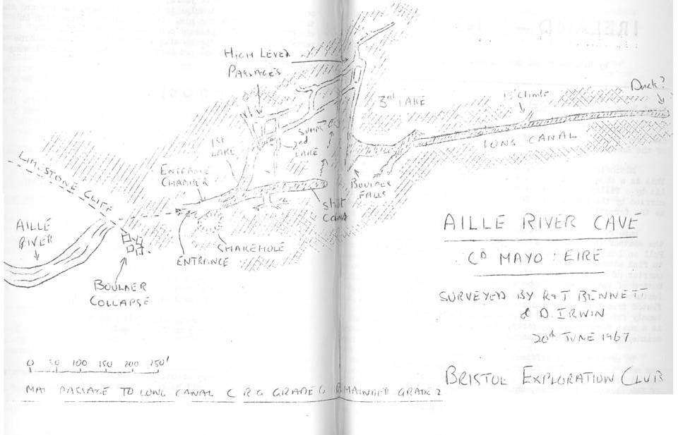
Note: Copies of the
Provisional Survey may be obtained from Bryan Ellis, Knockauns, Combwich,
Bridgwater,
*****************************************
Overheard outside the Hunters
.Alan Thomas praising a well
known caving club by saying The W****x is a fine club, its second to one on
Mendip!
*****************************************
If you can read this, it is highly likely that you can WRITE
as well. Why not prove your versatility
by writing something for the B.B.?
*****************************************
Dont forget that copies of all the B.E.C. Caving Reports
plus copies of most surveys of Mendip Caves, and many other publications are
available from: –
B.M. Ellis, Esq.,
Knockauns,
Combwich,
Bridgwater,
Somerset.
Send stamped addressed envelope for his complete list.